

-
 Snoflo Premium
Get unlimited access to all our content
With no Ad interruptions! - Start Your Free Trial Login with existing account
June-Lake
Eden Index
Climate
7.4
•
Recreation
10.0
•
Community
•
Safeguard
6.5/10
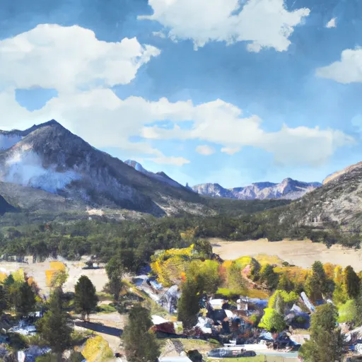
June Lake is a picturesque destination located in Mono County, California. Known for its stunning natural beauty and outdoor recreation opportunities, it attracts visitors throughout the year.
June Lake experiences a mild alpine climate, characterized by warm summers and cold winters. Average temperatures in summer range from 70-80°F, ideal for outdoor activities like hiking, fishing, and boating. Winters are cold, with temperatures often dropping below freezing and heavy snowfall, making it a popular spot for skiing and snowboarding enthusiasts.
The area is surrounded by several pristine lakes, including June Lake, Gull Lake, Silver Lake, and Grant Lake. These hydrologic constituents offer excellent fishing opportunities, with trout being the most common catch. Visitors can also enjoy water sports such as kayaking, paddleboarding, and swimming in the crystal-clear waters.
In addition to water-related activities, June Lake offers numerous hiking trails, including the breathtaking June Lake Loop. This loop showcases stunning vistas, wildflower meadows, and dramatic mountain peaks, attracting hikers and nature lovers. Other outdoor activities include mountain biking, rock climbing, and wildlife viewing.
Overall, June Lake, California, is a haven for outdoor enthusiasts, offering a diverse range of activities for visitors to immerse themselves in the natural beauty of the area.
What is the Eden Index?
The Snoflo Eden Index serves as a comprehensive rating system for regions, evaluating their desirability through a holistic assessment of climate health, outdoor recreation opportunities, and natural disaster risk, acknowledging the profound impact of these factors on livability and well-being.
Climate Health Indicator (CHI): 7.4
June-Lake receives approximately
627mm of rain per year,
with humidity levels near 64%
and air temperatures averaging around
5°C.
June-Lake has a plant hardyness factor of
6, meaning
plants and agriculture in this region thrive during a short period during spring and early summer. Most
plants will die off during the colder winter months.
By considering the ideal temperature range, reliable water supplies, clean air, and stable seasonal rain or snowpacks, the Climate Health Indicator (CHI) underscores the significance of a healthy climate as the foundation for quality living.
A healthy climate is paramount for ensuring a high quality of life and livability in a region, fostering both physical well-being and environmental harmony. This can be characterized by ideal temperatures, reliable access to water supplies, clean air, and consistent seasonal rain or snowpacks.
Weather Forecast
Streamflow Conditions
Mono-Owens Lakes
Area Rivers
Mono-Owens Lakes
Snowpack Depths
Mono-Owens Lakes
Reservoir Storage Capacity
Mono-Owens Lakes
Groundwater Levels
Recreational Opportunity Index (ROI): 10.0
The Recreational Opportunity Index (ROI) recognizes the value of outdoor recreational options, such as parks, hiking trails, camping sites, and fishing spots, while acknowledging that climate plays a pivotal role in ensuring the comfort and consistency of these experiences.
Access to outdoor recreational opportunities, encompassing activities such as parks, hiking, camping, and fishing, is crucial for overall well-being, and the climate plays a pivotal role in enabling and enhancing these experiences, ensuring that individuals can engage in nature-based activities comfortably and consistently.
Camping Areas
| Campground | Campsites | Reservations | Toilets | Showers | Elevation |
|---|---|---|---|---|---|
| Junction | 13 | 9,542 ft | |||
| Tioga Lake | 13 | 9,669 ft | |||
| Cattleguard | 15 | 7,268 ft | |||
| Saddlebag Lake | 20 | 10,182 ft | |||
| Lower Lee Vining | 60 | 7,334 ft | |||
| Trumbull Lake | 59 | 9,694 ft | |||
| Boulder | 10 | 7,411 ft | |||
| Ellery | 12 | 9,512 ft | |||
| Lundy Lake Park | 50 | 7,632 ft | |||
| Green Creek | 15 | 8,023 ft |
Nearby Ski Areas
Catastrophe Safeguard Index (CSI):
The Catastrophe Safeguard Index (CSI) recognizes that natural disaster risk, encompassing floods, fires, hurricanes, and tornadoes, can drastically affect safety and the overall appeal of an area.
The level of natural disaster risk in a region significantly affects safety and the overall livability, with climate change amplifying these risks by potentially increasing the frequency and intensity of events like floods, fires, hurricanes, and tornadoes, thereby posing substantial challenges to community resilience and well-being.
Community Resilience Indicator (CRI):
The Community Resilience Indicator (CRI) recognizes that education, healthcare, and socioeconomics are crucial to the well-being of a region. The CRI acknowledges the profound impact of these elements on residents' overall quality of life. By evaluating educational resources, healthcare accessibility, and economic inclusivity, the index captures the essential aspects that contribute to a thriving community, fostering resident satisfaction, equity, and social cohesion.