

-
 Snoflo Premium
Get unlimited access to all our content
With no Ad interruptions! - Start Your Free Trial Login with existing account
Springville
Eden Index
Climate
9.1
•
Recreation
7.5
•
Community
3.2
•
Safeguard
7.0/10
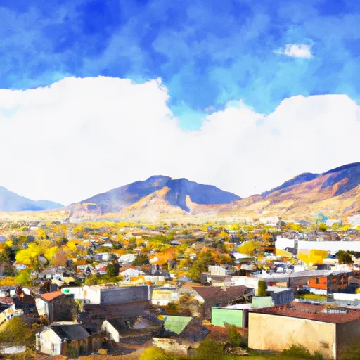
Springville is a charming city located in Utah, known for its beautiful surroundings and abundance of outdoor recreation opportunities. The climate in Springville is classified as semi-arid, with hot summers and cold winters. Summers are typically warm, with temperatures averaging in the high 80s Fahrenheit, while winters are cold and snowy, with average temperatures dipping below freezing.
Situated near the mouth of Hobble Creek Canyon, Springville benefits from its hydrology constituents. The nearby Provo River provides a source of freshwater, and Hobble Creek is a popular spot for fishing and exploring. The city also has several reservoirs, including the Hobble Creek Reservoir and the Springville Reservoir, offering opportunities for boating and water activities.
Outdoor enthusiasts will find plenty to enjoy in Springville. The city is surrounded by stunning natural beauty, with easy access to national parks, hiking trails, and camping areas. Nearby attractions include the breathtaking Provo Canyon, where visitors can hike, bike, or fish. The Spanish Fork Peak and Mount Timpanogos also offer challenging hiking trails and panoramic views.
In conclusion, Springville, Utah, offers a semi-arid climate with hot summers and cold winters. It benefits from its proximity to the Provo River and Hobble Creek, providing freshwater sources and excellent fishing opportunities. With its stunning natural surroundings and nearby outdoor attractions, Springville is the perfect destination for outdoor enthusiasts seeking adventure and exploration.
What is the Eden Index?
The Snoflo Eden Index serves as a comprehensive rating system for regions, evaluating their desirability through a holistic assessment of climate health, outdoor recreation opportunities, and natural disaster risk, acknowledging the profound impact of these factors on livability and well-being.
Climate Health Indicator (CHI): 9.1
Springville receives approximately
668mm of rain per year,
with humidity levels near 63%
and air temperatures averaging around
9°C.
Springville has a plant hardyness factor of
6, meaning
plants and agriculture in this region thrive during a short period during spring and early summer. Most
plants will die off during the colder winter months.
By considering the ideal temperature range, reliable water supplies, clean air, and stable seasonal rain or snowpacks, the Climate Health Indicator (CHI) underscores the significance of a healthy climate as the foundation for quality living.
A healthy climate is paramount for ensuring a high quality of life and livability in a region, fostering both physical well-being and environmental harmony. This can be characterized by ideal temperatures, reliable access to water supplies, clean air, and consistent seasonal rain or snowpacks.
Weather Forecast
Streamflow Conditions
Jordan
Area Rivers
Jordan
Snowpack Depths
Jordan
Reservoir Storage Capacity
Jordan
Groundwater Levels
Recreational Opportunity Index (ROI): 7.5
The Recreational Opportunity Index (ROI) recognizes the value of outdoor recreational options, such as parks, hiking trails, camping sites, and fishing spots, while acknowledging that climate plays a pivotal role in ensuring the comfort and consistency of these experiences.
Access to outdoor recreational opportunities, encompassing activities such as parks, hiking, camping, and fishing, is crucial for overall well-being, and the climate plays a pivotal role in enabling and enhancing these experiences, ensuring that individuals can engage in nature-based activities comfortably and consistently.
Camping Areas
| Campground | Campsites | Reservations | Toilets | Showers | Elevation |
|---|---|---|---|---|---|
| Tinney Flat | 13 | 7,063 ft | |||
| Canyon View RV Park | 25 | 4,719 ft | |||
| Payson Lakes | 113 | 7,981 ft | |||
| Maple Bench | 10 | 5,997 ft | |||
| Blackhawk | 15 | 7,962 ft | |||
| Maple Lake | 7 | 6,422 ft | |||
| Bear Canyon | 6 | 6,631 ft | |||
| Spanish Fork River Park | None | 4,966 ft | |||
| Unicorn | 26 | 7,242 ft | |||
| Ponderosa Uinta | 29 | 6,265 ft |
Nearby Ski Areas
Catastrophe Safeguard Index (CSI):
The Catastrophe Safeguard Index (CSI) recognizes that natural disaster risk, encompassing floods, fires, hurricanes, and tornadoes, can drastically affect safety and the overall appeal of an area.
The level of natural disaster risk in a region significantly affects safety and the overall livability, with climate change amplifying these risks by potentially increasing the frequency and intensity of events like floods, fires, hurricanes, and tornadoes, thereby posing substantial challenges to community resilience and well-being.
Community Resilience Indicator (CRI): 3.2
The Community Resilience Indicator (CRI) recognizes that education, healthcare, and socioeconomics are crucial to the well-being of a region. The CRI acknowledges the profound impact of these elements on residents' overall quality of life. By evaluating educational resources, healthcare accessibility, and economic inclusivity, the index captures the essential aspects that contribute to a thriving community, fostering resident satisfaction, equity, and social cohesion.