Lewis Creek Fishing
As of August 3, 2026, the nearest streamgauge to Lewis Creek — Nf Willow C Nr Sugar Pine Ca — reports 416 cfs. Source: USGS gauge data, refreshed throughout the day.
Community Reviews
Been here? Share the conditions.
Reviews, ratings & photos are added in the free Snoflo iOS app — rate a spot, tag the conditions, and your visit is verified by location. Add or manage your reviews from the app.
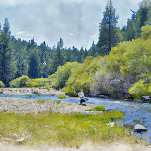
Lewis Creek
What's biting at Lewis Creek
Species commonly reported here -- tap any card for techniques, target seasons, and other waters where it's been caught.
Plan your trip down to the hour
Same weather feed Snoflo's iOS app uses -- updated continuously from NOAA / yr.no.
Next 5 days, hour by hour
Temperature line with weather symbols on top, snow + rain accumulation as columns, humidity as a dotted line.
5-day forecast table
Every 3 hours, broken out across temperature, snow, rain, humidity, and wind. Each cell is colour-coded relative to the column min/max so trends jump out at a glance.
| Time | Condition | Temp (°F) | Snow (in) | Rain (in) | Humidity (%) | Wind (mps) | Wind dir |
|---|---|---|---|---|---|---|---|
| Loading detailed forecast… | |||||||
15-day temperature & precipitation
Daily temperatures, snow, and rain projected over the next two weeks. Hover any point for the full breakdown.
Nearby streamflow
USGS streamgauges within reach of Lewis Creek -- updated continuously from the National Water Information System.
| Streamgauge | Discharge | View |
|---|---|---|
| Nf Willow C Nr Sugar Pine Ca | 416 cfs | → |
| Big C Div Nr Fish Camp Ca | 0 cfs | → |
| Merced R A Pohono Bridge Nr Yosemite Ca | 52 cfs | → |
| Merced R A Happy Isles Bridge Nr Yosemite Ca | 34 cfs | → |
| San Joaquin R Bl Friant Ca | 410 cfs | → |
| Mf San Joaquin R Nr Mammoth Lakes Ca | 27 cfs | → |
Plan a longer trip
The closest campgrounds, parks, boat launches, and reservoirs so a fishing run can grow into a weekend.
Campgrounds
- Kamook Staging Area
- Dusty Daisy Campsite
- Creekside Campsite
- Circle Grove Campsite
- Greys Mountain Campground
- Greys Mountain
Reservoirs
- Oakhurst Wastewater Treatment
- Chilkoot
- Crane Valley
- San Joaquin No. 3 Forebay
- Manzanita Diversion
- Upper Wilcox
Boat launches
- Bass Lake Water Sports And Marina
- Wishon Boat
- Mammoth Pool Rd, California
- Smalley Cove
- Redinger Lake
- Redinger Boating Site
Points of interest
- Yosemite Gateway Gallery Row
- Big Ed
- Bull Buck Tree
- Willow Creek Trail
- Bass Lake Boat Rentals
- Grizzly Giant
Paddle runs
- Confluence With North Fork San Joaquin River To Hells Half Acre
- Hemlock Crossing To Confluence With Cora Creek
- Cora Creek To Confluence With San Joaquin River
- Rainbow Falls To Confluence With North Fork San Joaquin River
- Headwaters In Sec 8, T3s, R25 E To Hemlock Crossing
- Headwaters Near The Tuolumne And Mariposa County Lines To Western Boundary Of Yosemite National Park
Angling safety & ethics
- Know the regulations
- Check local fishing rules, seasons, size limits, and license requirements to ensure legal and sustainable angling.
- Handle fish responsibly
- Use wet hands, minimize air exposure, and release fish gently to improve survival rates when practicing catch-and-release.
- Choose the right gear
- Match your rod, line, and tackle to the species and conditions to increase success and reduce unnecessary harm to fish.
- Respect the waterway
- Avoid disturbing habitat, prevent bank erosion, and keep a safe distance from spawning areas to protect ecosystems.
- Keep it clean
- Pack out all line, hooks, bait containers, and trash. Discarded gear can injure wildlife and degrade waterways.
Set push alerts in the Snoflo app
Save Lewis Creek as a favorite, set a custom threshold (water temperature, streamflow, snowpack), and the iOS app will push the moment conditions cross.
About Lewis Creek
What fish species are found at Lewis Creek?
Snoflo tracks the species commonly reported at Lewis Creek -- see the Fish Species panel above for the live list with images and links to per-species pages.
How fresh is the weather data on this page?
The hourly forecast updates throughout the day from the NOAA / yr.no public feeds. Streamflow data comes live from USGS streamgauges, also refreshed continuously.
Can I get alerts when conditions change?
Yes -- alerts are managed through the Snoflo iOS app. Favorite this area, set a threshold (water temperature, streamflow, snowpack), and you'll get a push the moment it crosses.
Do I need a fishing license?
Yes. Check your state agency's regulations for license requirements, seasons, size limits, and any waterbody-specific rules before fishing Lewis Creek.
How do I get to Lewis Creek?
Tap Open in map in the hero above to center the Snoflo interactive map on this area, or grab the coordinates from the location facts panel.
Other angling spots near here
Snoflo-tracked fishing areas within driving distance of Lewis Creek.