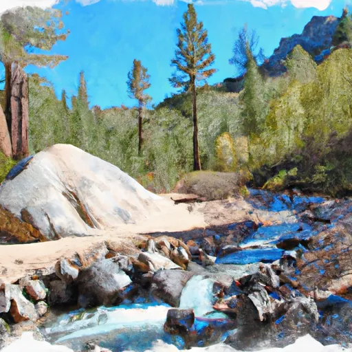
North Fork Headwaters At Mine Shaft Saddle To Nf Boundary River Run
Community Reviews
Been here? Share the conditions.
Reviews, ratings & photos are added in the free Snoflo iOS app — rate a spot, tag the conditions, and your visit is verified by location. Add or manage your reviews from the app.
North Fork Headwaters At Mine Shaft Saddle To Nf Boundary
The North Fork Headwaters segment is rated as a Class IV-V, which means that the river can have big and technical rapids, steep drops, and powerful currents. The segment mileage is approximately 8.5 miles, and it typically takes between 4-6 hours to complete.
Some of the specific rapids on this segment include Hell Hole, which is a Class V rapid that requires precise maneuvering to avoid a dangerous hole. Another notable rapid is Upper Staircase, which is a Class IV rapid with steep drops and technical moves.
There are specific regulations that paddlers must follow when visiting this area. The Whitewater River is part of the San Gorgonio Wilderness, and therefore, visitors must obtain a wilderness permit from the Forest Service before entering. Additionally, visitors must pack out all trash and use portable toilets or bury human waste to minimize environmental impact.
Overall, the North Fork Headwaters at Mine Shaft Saddle to NF Boundary segment on the Whitewater River is a challenging and exciting run that requires skill and experience to navigate safely. Paddlers must be aware of the ideal streamflow range, class rating, specific rapids, and regulations for the area to ensure a successful trip.
Plan your run down to the hour
Same weather feed Snoflo's iOS app uses -- updated continuously from NOAA / yr.no. Watch the precipitation column on the meteogram; rain ahead of a run typically lifts flows 12-48 hours later depending on the basin.
Next 5 days, hour by hour
Temperature line with weather symbols on top, snow + rain accumulation as columns, humidity as a dotted line.
5-day forecast table
Every 3 hours, broken out across temperature, snow, rain, humidity, and wind. Each cell is colour-coded relative to the column min/max.
| Time | Condition | Temp (°F) | Snow (in) | Rain (in) | Humidity (%) | Wind (mps) | Wind dir |
|---|---|---|---|---|---|---|---|
| Loading detailed forecast… | |||||||
15-day temperature & precipitation
Daily temperatures, snow, and rain projected over the next two weeks -- the upstream story that drives next week's flows.
Regional streamflow levels
USGS streamgauges around North Fork Headwaters At Mine Shaft Saddle To Nf Boundary -- useful for spotting upstream pulses and gauging which tributary is contributing what.
| Streamgauge | Discharge | View |
|---|---|---|
| Mission C Nr Desert Hot Springs Ca | 1 cfs | → |
| Whitewater R A Windy Point Main Channel Ca | 646 cfs | → |
| Whitewater R A Windy Point Overflow Channel Ca | · | → |
| Snow C Nr White Water Ca | · | → |
| Falls C Nr Whitewater Ca | 0 cfs | → |
| Chino Cyn C Bl Tramway Nr Palm Springs Ca | · | → |
Plan a longer trip
The closest boat launches, other paddle runs, and campgrounds so a day on the water can grow into a full weekend.
Boat launches
Other river runs
- South Fork - Wilderness Boundary/Sfdiversion Dam To Confluence With Mainstream
- Middle Fork Headwaters At Middle Fork Jumpoff To Confluence With North Fork
- Mission Creek
- West Fork Mission Creek
Campgrounds
Fishing spots
- Santa Ana River - South Fork
- Santa Ana River
- Mill Creek
- Lake Fulmor Day Use Area
- Lake Fulmor
- Fuller Mill Creek
Whitewater safety
- Check the flow before you run
- Use the linked-gauge card and Regional Flow panel above. Class ratings change with flow -- a Class III at low water can become Class IV+ at high water.
- Know your skill ceiling
- Pick runs comfortably below your ceiling. Cold-water and big-water runs raise the consequences of any mistake.
- Wear the right gear
- Helmet, PFD, drysuit / wetsuit when water is below 60°F. Throw bag, knife, and whistle on your person, not in the boat.
- Scout, set safety, and run with a team
- Scout new rapids on foot, set safety with throw bags above the consequence pool, and run with at least one other competent paddler.
- Respect the river
- Strainers, undercuts, low-head dams, and wood can kill at any class rating. When in doubt, portage.
Set push alerts in the Snoflo app
Save North Fork Headwaters At Mine Shaft Saddle To Nf Boundary as a favorite, set a discharge threshold (e.g. "alert me when flow hits 600 cfs"), and the iOS app pushes the moment the linked gauge crosses.
About North Fork Headwaters At Mine Shaft Saddle To Nf Boundary
What's the optimal flow for North Fork Headwaters At Mine Shaft Saddle To Nf Boundary?
The optimal flow depends on the section and the craft. Check the Run Details panel for the linked gauge and current status.
How fresh is the cfs reading on this page?
The linked USGS streamgauge reports continuously (every 15 minutes); Snoflo refreshes throughout the day. Hover the streamflow sparkline to read individual datapoints.
What's the whitewater class?
See the Run Details panel for the class rating Snoflo tracks for this run. Class ratings change with flow -- a Class III at low water can become Class IV in high water.
Where do I put in / take out?
Tap Directions in the hero above to open driving directions to the put-in. For shuttle planning, check the Nearby Boat Launches panel and the river run operator's site.
Can I get alerts when flows hit the optimal range?
Yes -- alerts are managed in the Snoflo iOS app. Favorite this run, set a discharge threshold, and you'll get a push the moment the gauge crosses.
Other runs near here
Snoflo-tracked paddle runs within driving distance of North Fork Headwaters At Mine Shaft Saddle To Nf Boundary.