Headwaters To Slate Reservoir River Run
Community Reviews
Been here? Share the conditions.
Reviews, ratings & photos are added in the free Snoflo iOS app — rate a spot, tag the conditions, and your visit is verified by location. Add or manage your reviews from the app.
Headwaters To Slate Reservoir
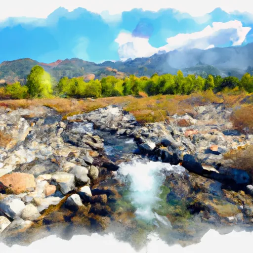
One of the most significant obstacles on this run is the Fishtail rapid, which is a narrow chute with a tricky entrance that requires precise maneuvering. The Sledgehammer rapid features a steep drop that requires careful navigation, while Triple Threat is a series of three consecutive rapids that require skill and precision to navigate.
There are specific regulations that visitors must follow when on this river run. All participants are required to wear a personal flotation device (PFD) at all times, and alcohol use is strictly prohibited. In addition, visitors are not allowed to camp or build fires within 300 feet of the river, and they must pack out all trash and waste.
Overall, the Whitewater River Run from Headwaters to Slate Reservoir is a challenging and exciting destination for experienced river runners. With the ideal streamflow range, Class III and IV rapids, and specific regulations in place, visitors can enjoy a safe and exhilarating adventure on this beautiful California river.
Plan your run down to the hour
Same weather feed Snoflo's iOS app uses -- updated continuously from NOAA / yr.no. Watch the precipitation column on the meteogram; rain ahead of a run typically lifts flows 12-48 hours later depending on the basin.
Next 5 days, hour by hour
Temperature line with weather symbols on top, snow + rain accumulation as columns, humidity as a dotted line.
5-day forecast table
Every 3 hours, broken out across temperature, snow, rain, humidity, and wind. Each cell is colour-coded relative to the column min/max.
| Time | Condition | Temp (°F) | Snow (in) | Rain (in) | Humidity (%) | Wind (mps) | Wind dir |
|---|---|---|---|---|---|---|---|
| Loading detailed forecast… | |||||||
15-day temperature & precipitation
Daily temperatures, snow, and rain projected over the next two weeks -- the upstream story that drives next week's flows.
Regional streamflow levels
USGS streamgauges around Headwaters To Slate Reservoir -- useful for spotting upstream pulses and gauging which tributary is contributing what.
| Streamgauge | Discharge | View |
|---|---|---|
| N Yuba R Bl Goodyears Bar Ca | 157 cfs | → |
| Spanish C A Quincy Ca | 15 cfs | → |
| Spanish C Ab Blackhawk C At Keddie Ca | 28 cfs | → |
| Deer C Nr Smartville Ca | 3 cfs | → |
| Butte C Nr Chico Ca | 170 cfs | → |
| Little Truckee R Bl Div Dam Nr Sierraville Ca | 3 cfs | → |
Plan a longer trip
The closest boat launches, other paddle runs, and campgrounds so a day on the water can grow into a full weekend.
Boat launches
- Mooreville
- Little Grass Valley (Black Rock Tent Camp)
- Peninsula Road, Strawberry Valley
- Plumas County
- Smokey Lane 44-50, Alleghany
- Bullards Bar Reservoir (Dark Day )
Other river runs
- Slate Reservoir To North Yuba River
- Confluence With South Fork Canyon Creek To Confluence With North Yuba River
- Headwaters Of North Yuba River (Sec 10, T20n, R13 E) To One-Eighth Mile Downstream Of Confluence With Cherokee Creek
- One-Eighth Mile Downstream From Confluence With Cherokee Creek To One-Quarter Mile Upstream From Confluence With Slate Creek
- One-Quarter Mile Upstream From Confluence With Slate Creek To Bullards Bar Reservoir Spillway (Elevation 1902 Feet)
Campgrounds
- Sly Creek Recreation Area
- Sly Creek
- Sly Creek Campground
- Golden Trout
- Golden Trout Crossing
- Cal-Ida Campground
Fishing spots
Whitewater safety
- Check the flow before you run
- Use the linked-gauge card and Regional Flow panel above. Class ratings change with flow -- a Class III at low water can become Class IV+ at high water.
- Know your skill ceiling
- Pick runs comfortably below your ceiling. Cold-water and big-water runs raise the consequences of any mistake.
- Wear the right gear
- Helmet, PFD, drysuit / wetsuit when water is below 60°F. Throw bag, knife, and whistle on your person, not in the boat.
- Scout, set safety, and run with a team
- Scout new rapids on foot, set safety with throw bags above the consequence pool, and run with at least one other competent paddler.
- Respect the river
- Strainers, undercuts, low-head dams, and wood can kill at any class rating. When in doubt, portage.
Set push alerts in the Snoflo app
Save Headwaters To Slate Reservoir as a favorite, set a discharge threshold (e.g. "alert me when flow hits 600 cfs"), and the iOS app pushes the moment the linked gauge crosses.
About Headwaters To Slate Reservoir
What's the optimal flow for Headwaters To Slate Reservoir?
The optimal flow depends on the section and the craft. Check the Run Details panel for the linked gauge and current status.
How fresh is the cfs reading on this page?
The linked USGS streamgauge reports continuously (every 15 minutes); Snoflo refreshes throughout the day. Hover the streamflow sparkline to read individual datapoints.
What's the whitewater class?
See the Run Details panel for the class rating Snoflo tracks for this run. Class ratings change with flow -- a Class III at low water can become Class IV in high water.
Where do I put in / take out?
Tap Directions in the hero above to open driving directions to the put-in. For shuttle planning, check the Nearby Boat Launches panel and the river run operator's site.
Can I get alerts when flows hit the optimal range?
Yes -- alerts are managed in the Snoflo iOS app. Favorite this run, set a discharge threshold, and you'll get a push the moment the gauge crosses.
Other runs near here
Snoflo-tracked paddle runs within driving distance of Headwaters To Slate Reservoir.