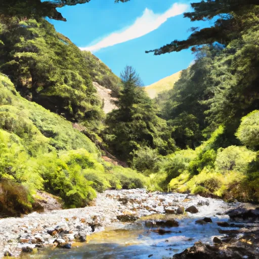
Headwaters North Fork Little Sur To Boy Scout Camp River Run
Community Reviews
Been here? Share the conditions.
Reviews, ratings & photos are added in the free Snoflo iOS app — rate a spot, tag the conditions, and your visit is verified by location. Add or manage your reviews from the app.
Headwaters North Fork Little Sur To Boy Scout Camp
Some of the notable rapids on this run include the Entrance Rapid, Pyrite Rapid, and the challenging Grizzly Rapid. Paddlers must navigate through steep drops and technical sections, including tight corners and boulder gardens. Additionally, rocks, tree branches, and other obstacles add to the challenge.
Regulations to the area include a permit requirement, which must be obtained prior to launching. Additionally, paddlers must adhere to Leave No Trace principles, such as packing out all trash and waste. The river is home to various wildlife species, including the California condor and steelhead trout, and paddlers are encouraged to respect their habitat.
Plan your run down to the hour
Same weather feed Snoflo's iOS app uses -- updated continuously from NOAA / yr.no. Watch the precipitation column on the meteogram; rain ahead of a run typically lifts flows 12-48 hours later depending on the basin.
Next 5 days, hour by hour
Temperature line with weather symbols on top, snow + rain accumulation as columns, humidity as a dotted line.
5-day forecast table
Every 3 hours, broken out across temperature, snow, rain, humidity, and wind. Each cell is colour-coded relative to the column min/max.
| Time | Condition | Temp (°F) | Snow (in) | Rain (in) | Humidity (%) | Wind (mps) | Wind dir |
|---|---|---|---|---|---|---|---|
| Loading detailed forecast… | |||||||
15-day temperature & precipitation
Daily temperatures, snow, and rain projected over the next two weeks -- the upstream story that drives next week's flows.
Regional streamflow levels
USGS streamgauges around Headwaters North Fork Little Sur To Boy Scout Camp -- useful for spotting upstream pulses and gauging which tributary is contributing what.
| Streamgauge | Discharge | View |
|---|---|---|
| Big Sur R Nr Big Sur Ca | 17 cfs | → |
| Carmel R A Robles Del Rio Ca | 8 cfs | → |
| Carmel R Nr Carmel Ca | 2 cfs | → |
| Salinas R Nr Chualar Ca | 55 cfs | → |
| Salinas R Nr Spreckels Ca | 15 cfs | → |
| Reclamation Ditch Nr Salinas Ca | 1 cfs | → |
Plan a longer trip
The closest boat launches, other paddle runs, and campgrounds so a day on the water can grow into a full weekend.
Other river runs
- Boy Scout Camp To Confluence With Mainstem Little Sur
- Headwaters South Fork Little Sur To Confluence With Mainstem Little Sur
- 0.25 Miles Downstream Of The Impoundment Of Sportsman's Lodge To Ventana Wilderness Boundary
- 0.25 Milesupstram Of The Impoundment At Sportsman's Lodge To 0.25 Miles Downstream Of The Impoundment At Sportsman's Lodge
- Headwaters To Sportsman's Club
Campgrounds
Whitewater safety
- Check the flow before you run
- Use the linked-gauge card and Regional Flow panel above. Class ratings change with flow -- a Class III at low water can become Class IV+ at high water.
- Know your skill ceiling
- Pick runs comfortably below your ceiling. Cold-water and big-water runs raise the consequences of any mistake.
- Wear the right gear
- Helmet, PFD, drysuit / wetsuit when water is below 60°F. Throw bag, knife, and whistle on your person, not in the boat.
- Scout, set safety, and run with a team
- Scout new rapids on foot, set safety with throw bags above the consequence pool, and run with at least one other competent paddler.
- Respect the river
- Strainers, undercuts, low-head dams, and wood can kill at any class rating. When in doubt, portage.
Set push alerts in the Snoflo app
Save Headwaters North Fork Little Sur To Boy Scout Camp as a favorite, set a discharge threshold (e.g. "alert me when flow hits 600 cfs"), and the iOS app pushes the moment the linked gauge crosses.
About Headwaters North Fork Little Sur To Boy Scout Camp
What's the optimal flow for Headwaters North Fork Little Sur To Boy Scout Camp?
The optimal flow depends on the section and the craft. Check the Run Details panel for the linked gauge and current status.
How fresh is the cfs reading on this page?
The linked USGS streamgauge reports continuously (every 15 minutes); Snoflo refreshes throughout the day. Hover the streamflow sparkline to read individual datapoints.
What's the whitewater class?
See the Run Details panel for the class rating Snoflo tracks for this run. Class ratings change with flow -- a Class III at low water can become Class IV in high water.
Where do I put in / take out?
Tap Directions in the hero above to open driving directions to the put-in. For shuttle planning, check the Nearby Boat Launches panel and the river run operator's site.
Can I get alerts when flows hit the optimal range?
Yes -- alerts are managed in the Snoflo iOS app. Favorite this run, set a discharge threshold, and you'll get a push the moment the gauge crosses.
Other runs near here
Snoflo-tracked paddle runs within driving distance of Headwaters North Fork Little Sur To Boy Scout Camp.