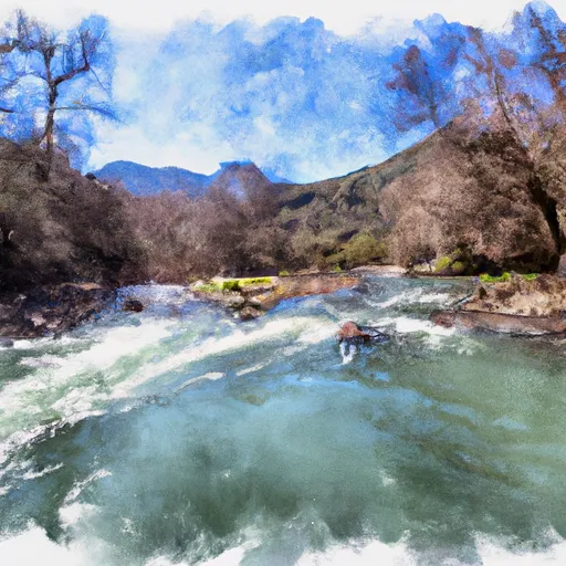
Paynes Creek River Run
Community Reviews
Been here? Share the conditions.
Reviews, ratings & photos are added in the free Snoflo iOS app — rate a spot, tag the conditions, and your visit is verified by location. Add or manage your reviews from the app.
Paynes Creek
The class rating for Paynes Creek is a Class III to IV, which means it is recommended for intermediate to advanced paddlers. The segment mileage of the river run is approximately 7 miles long and offers a variety of challenges to those who are up for it.
Some of the specific river rapids and obstacles that can be encountered on the Paynes Creek river run include "The Chute", "The Gorge", and "The Maze". These rapids are known for their technical difficulty, steep drops, and narrow channels.
In terms of regulations, it is important to obtain the necessary permits before entering the river. Additionally, all paddlers must wear a personal flotation device (PFD) and helmets are strongly recommended. It is also important to practice Leave No Trace principles and respect the natural environment.
Overall, Paynes Creek is a challenging and exciting whitewater river run that provides paddlers with a thrilling adventure. It is important to be prepared and follow all regulations to ensure a safe and enjoyable experience.
Plan your run down to the hour
Same weather feed Snoflo's iOS app uses -- updated continuously from NOAA / yr.no. Watch the precipitation column on the meteogram; rain ahead of a run typically lifts flows 12-48 hours later depending on the basin.
Next 5 days, hour by hour
Temperature line with weather symbols on top, snow + rain accumulation as columns, humidity as a dotted line.
5-day forecast table
Every 3 hours, broken out across temperature, snow, rain, humidity, and wind. Each cell is colour-coded relative to the column min/max.
| Time | Condition | Temp (°F) | Snow (in) | Rain (in) | Humidity (%) | Wind (mps) | Wind dir |
|---|---|---|---|---|---|---|---|
| Loading detailed forecast… | |||||||
15-day temperature & precipitation
Daily temperatures, snow, and rain projected over the next two weeks -- the upstream story that drives next week's flows.
Regional streamflow levels
USGS streamgauges around Paynes Creek -- useful for spotting upstream pulses and gauging which tributary is contributing what.
| Streamgauge | Discharge | View |
|---|---|---|
| Sacramento R Ab Bend Bridge Nr Red Bluff Ca | 13,300 cfs | → |
| Battle C Bl Coleman Fish Hatchery Nr Cottonwood Ca | 245 cfs | → |
| Cottonwood C Nr Cottonwood Ca | 64 cfs | → |
| Cow C Nr Millville Ca | 34 cfs | → |
| Mill C Nr Los Molinos Ca | 136 cfs | → |
| Deer C Nr Vina Ca | 99 cfs | → |
Plan a longer trip
The closest boat launches, other paddle runs, and campgrounds so a day on the water can grow into a full weekend.
Boat launches
- Jellys Ferry
- Jelly's Ferry
- Bend Bridge Fishing Access
- Balls Ferry Fishing Access
- Main Street 98, Red Bluff
- Sycamore Campground Boat Launch
Campgrounds
- Massacre Flat
- Massacre Flat Primitive Camping Area
- Reading Island
- Facht Place Campground
- Durango Rv Resort
- Camp Discovery Group Campground
Fishing spots
Parks
- William B Ide Adobe State Historic Park
- Forward Park
- Diamond Park
- Wildlife Area Tehama
- John R Trainor Park
- Anderson River Park
Points of interest
Whitewater safety
- Check the flow before you run
- Use the linked-gauge card and Regional Flow panel above. Class ratings change with flow -- a Class III at low water can become Class IV+ at high water.
- Know your skill ceiling
- Pick runs comfortably below your ceiling. Cold-water and big-water runs raise the consequences of any mistake.
- Wear the right gear
- Helmet, PFD, drysuit / wetsuit when water is below 60°F. Throw bag, knife, and whistle on your person, not in the boat.
- Scout, set safety, and run with a team
- Scout new rapids on foot, set safety with throw bags above the consequence pool, and run with at least one other competent paddler.
- Respect the river
- Strainers, undercuts, low-head dams, and wood can kill at any class rating. When in doubt, portage.
Set push alerts in the Snoflo app
Save Paynes Creek as a favorite, set a discharge threshold (e.g. "alert me when flow hits 600 cfs"), and the iOS app pushes the moment the linked gauge crosses.
About Paynes Creek
What's the optimal flow for Paynes Creek?
The optimal flow depends on the section and the craft. Check the Run Details panel for the linked gauge and current status.
How fresh is the cfs reading on this page?
The linked USGS streamgauge reports continuously (every 15 minutes); Snoflo refreshes throughout the day. Hover the streamflow sparkline to read individual datapoints.
What's the whitewater class?
See the Run Details panel for the class rating Snoflo tracks for this run. Class ratings change with flow -- a Class III at low water can become Class IV in high water.
Where do I put in / take out?
Tap Directions in the hero above to open driving directions to the put-in. For shuttle planning, check the Nearby Boat Launches panel and the river run operator's site.
Can I get alerts when flows hit the optimal range?
Yes -- alerts are managed in the Snoflo iOS app. Favorite this run, set a discharge threshold, and you'll get a push the moment the gauge crosses.
Other runs near here
Snoflo-tracked paddle runs within driving distance of Paynes Creek.