Cottonwood Creek River Run
Community Reviews
Been here? Share the conditions.
Reviews, ratings & photos are added in the free Snoflo iOS app — rate a spot, tag the conditions, and your visit is verified by location. Add or manage your reviews from the app.
Cottonwood Creek
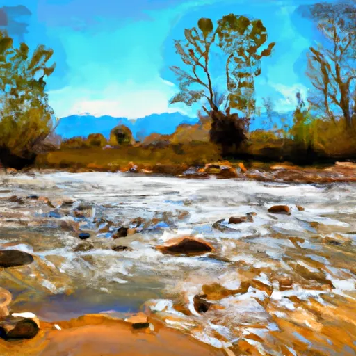
The river rapids and obstacles on this run include the "Cottonwood Falls," a Class IV rapid that requires precise boat control and navigation through a tight channel. Other notable rapids include "The Notch," "The Squeeze," and "The Pinch," all of which are Class III-IV rapids that require technical skill and experience.
There are specific regulations to the area that visitors should be aware of before planning a trip to Cottonwood Creek. The area is managed by the Bureau of Land Management and visitors are required to obtain a permit before accessing the river. Additionally, visitors are expected to follow Leave No Trace principles and pack out all trash and waste. Camping is prohibited along the riverbank, and fires are only allowed in designated fire rings.
Overall, Cottonwood Creek provides a challenging and scenic whitewater experience for experienced kayakers and rafters. It is important to check the streamflow range and weather conditions before embarking on this river run, and to follow all regulations to ensure the protection of this beautiful natural resource.
Plan your run down to the hour
Same weather feed Snoflo's iOS app uses -- updated continuously from NOAA / yr.no. Watch the precipitation column on the meteogram; rain ahead of a run typically lifts flows 12-48 hours later depending on the basin.
Next 5 days, hour by hour
Temperature line with weather symbols on top, snow + rain accumulation as columns, humidity as a dotted line.
5-day forecast table
Every 3 hours, broken out across temperature, snow, rain, humidity, and wind. Each cell is colour-coded relative to the column min/max.
| Time | Condition | Temp (°F) | Snow (in) | Rain (in) | Humidity (%) | Wind (mps) | Wind dir |
|---|---|---|---|---|---|---|---|
| Loading detailed forecast… | |||||||
15-day temperature & precipitation
Daily temperatures, snow, and rain projected over the next two weeks -- the upstream story that drives next week's flows.
Regional streamflow levels
USGS streamgauges around Cottonwood Creek -- useful for spotting upstream pulses and gauging which tributary is contributing what.
| Streamgauge | Discharge | View |
|---|---|---|
| Arkansas River At Parkdale | 217 cfs | → |
| Fourmile Creek Below Cripple Creek Near Victor | 4 cfs | → |
| Arkansas River At Canon City | 165 cfs | → |
| South Platte River Near Lake George | 98 cfs | → |
| Arkansas River Near Wellsville | 200 cfs | → |
| Beaver Cr Abv Upper Beaver Cemetery Nr Penrose | 4 cfs | → |
Plan a longer trip
The closest boat launches, other paddle runs, and campgrounds so a day on the water can grow into a full weekend.
Boat launches
- Arkansas Headwaters Recreation Area
- Ahra - Spikebuck Rec Site
- Ahra - Parkdale Rec Site
- Ahra - Pinnacle Rock Rec Site
Other river runs
Campgrounds
- Prospectors Rv Resort
- Royal View Campground
- Five Points - Arkansas Headwaters State Rec Area
- Sand Gulch Campground Campsite 6
- Sand Gulch Campground Campsite 5
- Sand Gulch Campground Campsite 7
Whitewater safety
- Check the flow before you run
- Use the linked-gauge card and Regional Flow panel above. Class ratings change with flow -- a Class III at low water can become Class IV+ at high water.
- Know your skill ceiling
- Pick runs comfortably below your ceiling. Cold-water and big-water runs raise the consequences of any mistake.
- Wear the right gear
- Helmet, PFD, drysuit / wetsuit when water is below 60°F. Throw bag, knife, and whistle on your person, not in the boat.
- Scout, set safety, and run with a team
- Scout new rapids on foot, set safety with throw bags above the consequence pool, and run with at least one other competent paddler.
- Respect the river
- Strainers, undercuts, low-head dams, and wood can kill at any class rating. When in doubt, portage.
Set push alerts in the Snoflo app
Save Cottonwood Creek as a favorite, set a discharge threshold (e.g. "alert me when flow hits 600 cfs"), and the iOS app pushes the moment the linked gauge crosses.
About Cottonwood Creek
What's the optimal flow for Cottonwood Creek?
The optimal flow depends on the section and the craft. Check the Run Details panel for the linked gauge and current status.
How fresh is the cfs reading on this page?
The linked USGS streamgauge reports continuously (every 15 minutes); Snoflo refreshes throughout the day. Hover the streamflow sparkline to read individual datapoints.
What's the whitewater class?
See the Run Details panel for the class rating Snoflo tracks for this run. Class ratings change with flow -- a Class III at low water can become Class IV in high water.
Where do I put in / take out?
Tap Directions in the hero above to open driving directions to the put-in. For shuttle planning, check the Nearby Boat Launches panel and the river run operator's site.
Can I get alerts when flows hit the optimal range?
Yes -- alerts are managed in the Snoflo iOS app. Favorite this run, set a discharge threshold, and you'll get a push the moment the gauge crosses.
Other runs near here
Snoflo-tracked paddle runs within driving distance of Cottonwood Creek.