Colorado River Segment 5 river run
Community Reviews
Been here? Share the conditions.
Reviews, ratings & photos are added in the free Snoflo iOS app — rate a spot, tag the conditions, and your visit is verified by location. Add or manage your reviews from the app.
Colorado River Segment 5
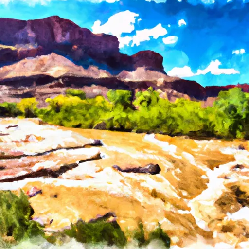
This segment is rated as a Class III-IV, with several notable rapids and obstacles along the way. Some of the major rapids include the Eye of the Needle, the Wall, and the No Name Rapid. These rapids feature tight channels and technical maneuvers, making them a thrilling challenge for experienced rafters.
The segment covers a distance of approximately 9 miles, starting at the Grizzly Creek Rest Area and ending at the Two Rivers Park in Glenwood Springs. Along the way, rafters will enjoy stunning views of the surrounding mountains and canyons.
Specific regulations for the Whitewater River Run include a minimum age requirement of 15 years old for rafting during peak season, and 10 years old during lower flow periods. All participants must wear a personal flotation device (PFD) at all times, and alcohol and drug use are strictly prohibited.
Overall, the Whitewater River Run is a challenging and exciting stretch of river for experienced rafters, with beautiful scenery and plenty of thrills along the way.
Plan your run down to the hour
Same weather feed Snoflo's iOS app uses -- updated continuously from NOAA / yr.no. Watch the precipitation column on the meteogram; rain ahead of a run typically lifts flows 12-48 hours later depending on the basin.
Next 5 days, hour by hour
Temperature line with weather symbols on top, snow + rain accumulation as columns, humidity as a dotted line.
5-day forecast table
Every 3 hours, broken out across temperature, snow, rain, humidity, and wind. Each cell is colour-coded relative to the column min/max.
| Time | Condition | Temp (°F) | Snow (in) | Rain (in) | Humidity (%) | Wind (mps) | Wind dir |
|---|---|---|---|---|---|---|---|
| Loading detailed forecast… | |||||||
15-day temperature & precipitation
Daily temperatures, snow, and rain projected over the next two weeks -- the upstream story that drives next week's flows.
Regional streamflow levels
USGS streamgauges around Colorado River Segment 5 -- useful for spotting upstream pulses and gauging which tributary is contributing what.
| Streamgauge | Discharge | View |
|---|---|---|
| Colorado River Near Kremmling | 1,140 cfs | → |
| Muddy Crk Blw Wolford Mtn Reser. Nr Kremmling | 236 cfs | → |
| Blue River Below Green Mountain Reservoir | 444 cfs | → |
| Piney River Near State Bridge | 9 cfs | → |
| Muddy Creek Above Antelope Creek Nr. Kremmling | 2 cfs | → |
| Williams Fork Below Williams Fork Reservoir | 469 cfs | → |
Plan a longer trip
The closest boat launches, other paddle runs, and campgrounds so a day on the water can grow into a full weekend.
Boat launches
- Radium Rec Site Boat Ramp
- Confluence Rec Site Boat Ramp
- State Bridge Boat Ramp
- State Bridge River Access
- Two Bridges Boat Ramp
- Co 9 Summit County
Other river runs
- Pumphouse
- Colorado River Segment 4
- Gore Canyon
- South Section Line Sec 34, T1n, R83w To Confluence With Decker Creek
- State Bridge To Burns
Campgrounds
- Pumphouse Rec Site Campsite
- Ueberfluss Campsite
- Pumphouse Rec. Site Campground
- Pumphouse Rec Group Campsite A
- Pumphouse Rec Group Campsite B
- Pumphouse
Whitewater safety
- Check the flow before you run
- Use the linked-gauge card and Regional Flow panel above. Class ratings change with flow -- a Class III at low water can become Class IV+ at high water.
- Know your skill ceiling
- Pick runs comfortably below your ceiling. Cold-water and big-water runs raise the consequences of any mistake.
- Wear the right gear
- Helmet, PFD, drysuit / wetsuit when water is below 60°F. Throw bag, knife, and whistle on your person, not in the boat.
- Scout, set safety, and run with a team
- Scout new rapids on foot, set safety with throw bags above the consequence pool, and run with at least one other competent paddler.
- Respect the river
- Strainers, undercuts, low-head dams, and wood can kill at any class rating. When in doubt, portage.
Set push alerts in the Snoflo app
Save Colorado River Segment 5 as a favorite, set a discharge threshold (e.g. "alert me when flow hits 600 cfs"), and the iOS app pushes the moment the linked gauge crosses.
About Colorado River Segment 5
What's the optimal flow for Colorado River Segment 5?
The optimal flow depends on the section and the craft. Check the Run Details panel for the linked gauge and current status.
How fresh is the cfs reading on this page?
The linked USGS streamgauge reports continuously (every 15 minutes); Snoflo refreshes throughout the day. Hover the streamflow sparkline to read individual datapoints.
What's the whitewater class?
See the Run Details panel for the class rating Snoflo tracks for this run. Class ratings change with flow -- a Class III at low water can become Class IV in high water.
Where do I put in / take out?
Tap Directions in the hero above to open driving directions to the put-in. For shuttle planning, check the Nearby Boat Launches panel and the river run operator's site.
Can I get alerts when flows hit the optimal range?
Yes -- alerts are managed in the Snoflo iOS app. Favorite this run, set a discharge threshold, and you'll get a push the moment the gauge crosses.
Other runs near here
Snoflo-tracked paddle runs within driving distance of Colorado River Segment 5.