Beginning Of Blue Sky To End Of Blue Sky River Run
Community Reviews
Been here? Share the conditions.
Reviews, ratings & photos are added in the free Snoflo iOS app — rate a spot, tag the conditions, and your visit is verified by location. Add or manage your reviews from the app.
Beginning Of Blue Sky To End Of Blue Sky
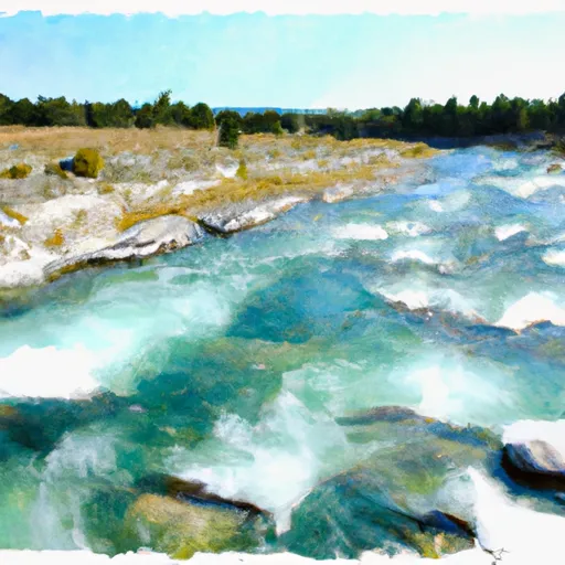
One of the most notable rapids on this segment is the Jaws, which is a Class III rapid with a steep drop and large waves. The rapid can be challenging for inexperienced paddlers, and caution is advised. Other notable rapids include the Pinball and the Subway.
Several regulations apply to this area. Boaters are required to have a personal flotation device (PFD) for each person on board. Additionally, boaters are required to carry a signal device, such as a whistle or mirror, and a first aid kit. The use of alcohol or drugs while on the river is prohibited.
In conclusion, the Whitewater River Run Beginning of Blue Sky to End of Blue Sky is a popular rafting destination in Montana. The ideal streamflow range is between 1,500 and 3,500 cfs, and the river is classified as Class II-III. Notable rapids include Jaws, Pinball, and Subway. Specific regulations applicable to the area include the use of PFDs, signal devices, and a ban on alcohol and drugs.
Plan your run down to the hour
Same weather feed Snoflo's iOS app uses -- updated continuously from NOAA / yr.no. Watch the precipitation column on the meteogram; rain ahead of a run typically lifts flows 12-48 hours later depending on the basin.
Next 5 days, hour by hour
Temperature line with weather symbols on top, snow + rain accumulation as columns, humidity as a dotted line.
5-day forecast table
Every 3 hours, broken out across temperature, snow, rain, humidity, and wind. Each cell is colour-coded relative to the column min/max.
| Time | Condition | Temp (°F) | Snow (in) | Rain (in) | Humidity (%) | Wind (mps) | Wind dir |
|---|---|---|---|---|---|---|---|
| Loading detailed forecast… | |||||||
15-day temperature & precipitation
Daily temperatures, snow, and rain projected over the next two weeks -- the upstream story that drives next week's flows.
Regional streamflow levels
USGS streamgauges around Beginning Of Blue Sky To End Of Blue Sky -- useful for spotting upstream pulses and gauging which tributary is contributing what.
| Streamgauge | Discharge | View |
|---|---|---|
| Flathead River At Flathead British Columbia | 528 cfs | → |
| Tobacco River Near Eureka Mt | 388 cfs | → |
| N F Flathead River Nr Columbia Falls Mt | 2,090 cfs | → |
| Middle Fork Flathead River Nr West Glacier Mt | 2,150 cfs | → |
| Kootenai River Bl Libby Dam Nr Libby Mt | 9,070 cfs | → |
| Flathead River At Columbia Falls Mt | 7,570 cfs | → |
Plan a longer trip
The closest boat launches, other paddle runs, and campgrounds so a day on the water can grow into a full weekend.
Other river runs
- Grave Creek System
- Beginning Of Stahl Creek To End Of Stahl Creek
- Beginning Of Clarence Creek To End Of Clarence Creek
- Border To Polebridge
- Polebridge To Big Creek
Campgrounds
- Clarence Creek Campground
- Ninko Cabin
- Grave Creek Campground
- Tuchuck Campground
- Tuchuck
- Red Meadow Lake Campground
Fishing spots
Whitewater safety
- Check the flow before you run
- Use the linked-gauge card and Regional Flow panel above. Class ratings change with flow -- a Class III at low water can become Class IV+ at high water.
- Know your skill ceiling
- Pick runs comfortably below your ceiling. Cold-water and big-water runs raise the consequences of any mistake.
- Wear the right gear
- Helmet, PFD, drysuit / wetsuit when water is below 60°F. Throw bag, knife, and whistle on your person, not in the boat.
- Scout, set safety, and run with a team
- Scout new rapids on foot, set safety with throw bags above the consequence pool, and run with at least one other competent paddler.
- Respect the river
- Strainers, undercuts, low-head dams, and wood can kill at any class rating. When in doubt, portage.
Set push alerts in the Snoflo app
Save Beginning Of Blue Sky To End Of Blue Sky as a favorite, set a discharge threshold (e.g. "alert me when flow hits 600 cfs"), and the iOS app pushes the moment the linked gauge crosses.
About Beginning Of Blue Sky To End Of Blue Sky
What's the optimal flow for Beginning Of Blue Sky To End Of Blue Sky?
The optimal flow depends on the section and the craft. Check the Run Details panel for the linked gauge and current status.
How fresh is the cfs reading on this page?
The linked USGS streamgauge reports continuously (every 15 minutes); Snoflo refreshes throughout the day. Hover the streamflow sparkline to read individual datapoints.
What's the whitewater class?
See the Run Details panel for the class rating Snoflo tracks for this run. Class ratings change with flow -- a Class III at low water can become Class IV in high water.
Where do I put in / take out?
Tap Directions in the hero above to open driving directions to the put-in. For shuttle planning, check the Nearby Boat Launches panel and the river run operator's site.
Can I get alerts when flows hit the optimal range?
Yes -- alerts are managed in the Snoflo iOS app. Favorite this run, set a discharge threshold, and you'll get a push the moment the gauge crosses.
Other runs near here
Snoflo-tracked paddle runs within driving distance of Beginning Of Blue Sky To End Of Blue Sky.