Beginning Of Stahl Creek To End Of Stahl Creek River Run
Community Reviews
Been here? Share the conditions.
Reviews, ratings & photos are added in the free Snoflo iOS app — rate a spot, tag the conditions, and your visit is verified by location. Add or manage your reviews from the app.
Beginning Of Stahl Creek To End Of Stahl Creek
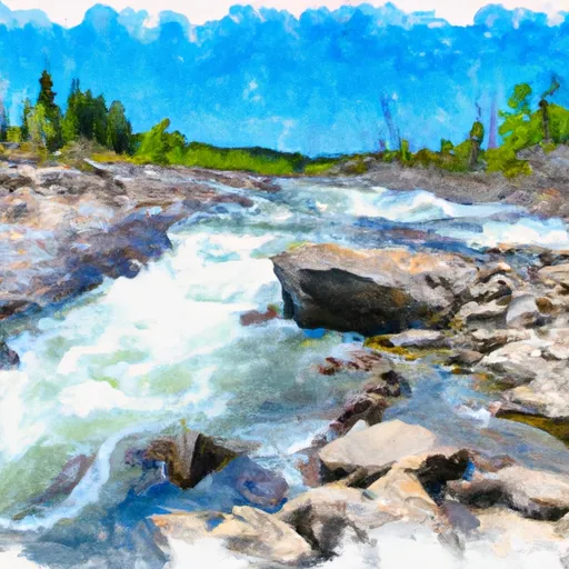
The river rapids and obstacles on this run include "Jaws" at the beginning of the run, which is a Class IV rapid with a steep drop and strong currents. "The Gauntlet" is another Class IV rapid with a narrow chute and large rocks, and "Pinball" is a Class III rapid with multiple rocks and drops.
It is important to note that due to the high difficulty level of this run, paddlers are required to have prior experience on Class IV rapids and must wear proper safety equipment, including a helmet and a personal flotation device. Additionally, there are specific regulations to this area, including a limit of 12 people per group and no overnight camping.
Plan your run down to the hour
Same weather feed Snoflo's iOS app uses -- updated continuously from NOAA / yr.no. Watch the precipitation column on the meteogram; rain ahead of a run typically lifts flows 12-48 hours later depending on the basin.
Next 5 days, hour by hour
Temperature line with weather symbols on top, snow + rain accumulation as columns, humidity as a dotted line.
5-day forecast table
Every 3 hours, broken out across temperature, snow, rain, humidity, and wind. Each cell is colour-coded relative to the column min/max.
| Time | Condition | Temp (°F) | Snow (in) | Rain (in) | Humidity (%) | Wind (mps) | Wind dir |
|---|---|---|---|---|---|---|---|
| Loading detailed forecast… | |||||||
15-day temperature & precipitation
Daily temperatures, snow, and rain projected over the next two weeks -- the upstream story that drives next week's flows.
Regional streamflow levels
USGS streamgauges around Beginning Of Stahl Creek To End Of Stahl Creek -- useful for spotting upstream pulses and gauging which tributary is contributing what.
| Streamgauge | Discharge | View |
|---|---|---|
| Tobacco River Near Eureka Mt | 388 cfs | → |
| Flathead River At Flathead British Columbia | 610 cfs | → |
| Kootenai River Bl Libby Dam Nr Libby Mt | 9,010 cfs | → |
| Fisher River Near Libby Mt | 109 cfs | → |
| N F Flathead River Nr Columbia Falls Mt | 2,560 cfs | → |
| Middle Fork Flathead River Nr West Glacier Mt | 2,570 cfs | → |
Plan a longer trip
The closest boat launches, other paddle runs, and campgrounds so a day on the water can grow into a full weekend.
Boat launches
- Glen Lake
- Tetrault Lake
- Sophie Lake
- Sophie Lake Road Lincoln County
- Abayance Bay Marina-Rexford
- Canadian Border River Access Boating Site
Other river runs
- Beginning Of Clarence Creek To End Of Clarence Creek
- Grave Creek System
- Beginning Of Blue Sky To End Of Blue Sky
- Border To Polebridge
- Big Creek Bridge Adjacent To Lake Koocanusa, Sec. 33, T35n, R29w To North And South Fork Of Big Creek
Whitewater safety
- Check the flow before you run
- Use the linked-gauge card and Regional Flow panel above. Class ratings change with flow -- a Class III at low water can become Class IV+ at high water.
- Know your skill ceiling
- Pick runs comfortably below your ceiling. Cold-water and big-water runs raise the consequences of any mistake.
- Wear the right gear
- Helmet, PFD, drysuit / wetsuit when water is below 60°F. Throw bag, knife, and whistle on your person, not in the boat.
- Scout, set safety, and run with a team
- Scout new rapids on foot, set safety with throw bags above the consequence pool, and run with at least one other competent paddler.
- Respect the river
- Strainers, undercuts, low-head dams, and wood can kill at any class rating. When in doubt, portage.
Set push alerts in the Snoflo app
Save Beginning Of Stahl Creek To End Of Stahl Creek as a favorite, set a discharge threshold (e.g. "alert me when flow hits 600 cfs"), and the iOS app pushes the moment the linked gauge crosses.
About Beginning Of Stahl Creek To End Of Stahl Creek
What's the optimal flow for Beginning Of Stahl Creek To End Of Stahl Creek?
The optimal flow depends on the section and the craft. Check the Run Details panel for the linked gauge and current status.
How fresh is the cfs reading on this page?
The linked USGS streamgauge reports continuously (every 15 minutes); Snoflo refreshes throughout the day. Hover the streamflow sparkline to read individual datapoints.
What's the whitewater class?
See the Run Details panel for the class rating Snoflo tracks for this run. Class ratings change with flow -- a Class III at low water can become Class IV in high water.
Where do I put in / take out?
Tap Directions in the hero above to open driving directions to the put-in. For shuttle planning, check the Nearby Boat Launches panel and the river run operator's site.
Can I get alerts when flows hit the optimal range?
Yes -- alerts are managed in the Snoflo iOS app. Favorite this run, set a discharge threshold, and you'll get a push the moment the gauge crosses.
Other runs near here
Snoflo-tracked paddle runs within driving distance of Beginning Of Stahl Creek To End Of Stahl Creek.