Fall Creek - Salem River Run
Community Reviews
Been here? Share the conditions.
Reviews, ratings & photos are added in the free Snoflo iOS app — rate a spot, tag the conditions, and your visit is verified by location. Add or manage your reviews from the app.
Fall Creek - Salem
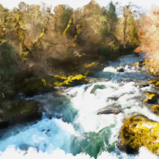
The segment mileage for the Whitewater River Run Fall Creek is approximately 9 miles, starting at the Fall Creek Reservoir and ending at the confluence with the Middle Fork of the Willamette River. The river features a variety of rapids and obstacles, including Big Island, Pinball, and the Narrows, which provide exciting challenges for experienced paddlers.
Specific regulations for the area include the requirement for life jackets and helmets for all paddlers. Additionally, all commercial outfitters must be licensed by the state and have properly trained guides on all trips. The area is also subject to seasonal closures and restrictions, so it is important to check with local authorities before planning a trip.
Overall, the Whitewater River Run Fall Creek is a thrilling adventure for experienced paddlers looking for a challenging and scenic river run. It is important to plan ahead, check the streamflow conditions, and follow all regulations to ensure a safe and enjoyable trip.
Plan your run down to the hour
Same weather feed Snoflo's iOS app uses -- updated continuously from NOAA / yr.no. Watch the precipitation column on the meteogram; rain ahead of a run typically lifts flows 12-48 hours later depending on the basin.
Next 5 days, hour by hour
Temperature line with weather symbols on top, snow + rain accumulation as columns, humidity as a dotted line.
5-day forecast table
Every 3 hours, broken out across temperature, snow, rain, humidity, and wind. Each cell is colour-coded relative to the column min/max.
| Time | Condition | Temp (°F) | Snow (in) | Rain (in) | Humidity (%) | Wind (mps) | Wind dir |
|---|---|---|---|---|---|---|---|
| Loading detailed forecast… | |||||||
15-day temperature & precipitation
Daily temperatures, snow, and rain projected over the next two weeks -- the upstream story that drives next week's flows.
Regional streamflow levels
USGS streamgauges around Fall Creek - Salem -- useful for spotting upstream pulses and gauging which tributary is contributing what.
| Streamgauge | Discharge | View |
|---|---|---|
| Alsea River Near Tidewater | 80 cfs | → |
| East Fork Lobster Creek Near Alsea | 1 cfs | → |
| Marys River Near Philomath | 12 cfs | → |
| Long Tom River At Monroe | 56 cfs | → |
| Siletz River At Siletz | 83 cfs | → |
| Willamette River At Corvallis | 3,960 cfs | → |
Plan a longer trip
The closest boat launches, other paddle runs, and campgrounds so a day on the water can grow into a full weekend.
Boat launches
Other river runs
Campgrounds
- Salmonberry County Park Campground
- River Edge Group Campground
- Marys Peak Campground
- Marys Peak
- Big Elk Campground
- Blackberry Campground
Whitewater safety
- Check the flow before you run
- Use the linked-gauge card and Regional Flow panel above. Class ratings change with flow -- a Class III at low water can become Class IV+ at high water.
- Know your skill ceiling
- Pick runs comfortably below your ceiling. Cold-water and big-water runs raise the consequences of any mistake.
- Wear the right gear
- Helmet, PFD, drysuit / wetsuit when water is below 60°F. Throw bag, knife, and whistle on your person, not in the boat.
- Scout, set safety, and run with a team
- Scout new rapids on foot, set safety with throw bags above the consequence pool, and run with at least one other competent paddler.
- Respect the river
- Strainers, undercuts, low-head dams, and wood can kill at any class rating. When in doubt, portage.
Set push alerts in the Snoflo app
Save Fall Creek - Salem as a favorite, set a discharge threshold (e.g. "alert me when flow hits 600 cfs"), and the iOS app pushes the moment the linked gauge crosses.
About Fall Creek - Salem
What's the optimal flow for Fall Creek - Salem?
The optimal flow depends on the section and the craft. Check the Run Details panel for the linked gauge and current status.
How fresh is the cfs reading on this page?
The linked USGS streamgauge reports continuously (every 15 minutes); Snoflo refreshes throughout the day. Hover the streamflow sparkline to read individual datapoints.
What's the whitewater class?
See the Run Details panel for the class rating Snoflo tracks for this run. Class ratings change with flow -- a Class III at low water can become Class IV in high water.
Where do I put in / take out?
Tap Directions in the hero above to open driving directions to the put-in. For shuttle planning, check the Nearby Boat Launches panel and the river run operator's site.
Can I get alerts when flows hit the optimal range?
Yes -- alerts are managed in the Snoflo iOS app. Favorite this run, set a discharge threshold, and you'll get a push the moment the gauge crosses.
Other runs near here
Snoflo-tracked paddle runs within driving distance of Fall Creek - Salem.