Source To Trailhead River Run
Community Reviews
Been here? Share the conditions.
Reviews, ratings & photos are added in the free Snoflo iOS app — rate a spot, tag the conditions, and your visit is verified by location. Add or manage your reviews from the app.
Source To Trailhead
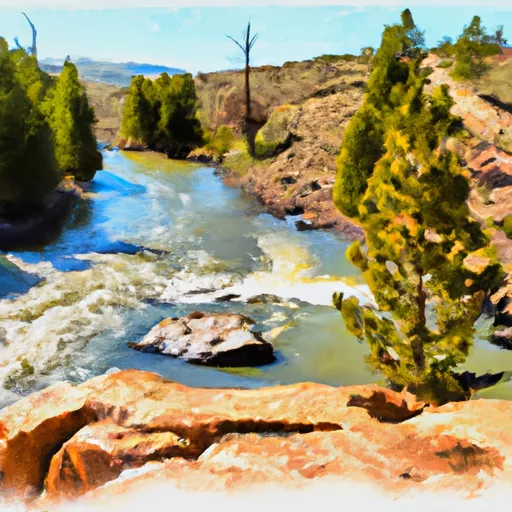
The Whitewater River Run Source to Trailhead is a popular river run in Wyoming, known for its exciting rapids and stunning scenery. The ideal streamflow range for this run is between 800 and 2,000 cfs, depending on the season and recent weather conditions. The class rating for this run is mostly Class III, with some Class IV rapids and obstacles scattered throughout the course. The segment mileage for this run is approximately 12 miles, starting at the source of the Whitewater River and ending at the Trailhead.
Some of the specific rapids and obstacles you can expect to encounter during this run include the Ledge Drop, the Pinball Rapid, and the Roller Coaster. These rapids are known for their challenging features, such as steep drops, large waves, and tight channels. If you're new to whitewater rafting, it's important to note that this run can be quite technical and requires some experience and skill to navigate safely.
In addition to the rapids themselves, there are also specific regulations to be aware of when rafting this run. For example, all participants must wear a life jacket and helmet, and commercial operators must have a valid permit from the National Park Service. Additionally, there are restrictions on the number of guests per raft, and alcohol is not allowed on the river.
Overall, the Whitewater River Run Source to Trailhead is a thrilling and challenging river run that's suitable for experienced rafters looking for an exciting adventure. As with any whitewater activity, it's important to exercise caution and follow all safety regulations to ensure a fun and safe trip.
Plan your run down to the hour
Same weather feed Snoflo's iOS app uses -- updated continuously from NOAA / yr.no. Watch the precipitation column on the meteogram; rain ahead of a run typically lifts flows 12-48 hours later depending on the basin.
Next 5 days, hour by hour
Temperature line with weather symbols on top, snow + rain accumulation as columns, humidity as a dotted line.
5-day forecast table
Every 3 hours, broken out across temperature, snow, rain, humidity, and wind. Each cell is colour-coded relative to the column min/max.
| Time | Condition | Temp (°F) | Snow (in) | Rain (in) | Humidity (%) | Wind (mps) | Wind dir |
|---|---|---|---|---|---|---|---|
| Loading detailed forecast… | |||||||
15-day temperature & precipitation
Daily temperatures, snow, and rain projected over the next two weeks -- the upstream story that drives next week's flows.
Regional streamflow levels
USGS streamgauges around Source To Trailhead -- useful for spotting upstream pulses and gauging which tributary is contributing what.
| Streamgauge | Discharge | View |
|---|---|---|
| Snake River Ab Reservoir Nr Alpine Wy | 7,280 cfs | → |
| Greys River Ab Reservoir Nr Alpine Wy | 419 cfs | → |
| Salt River Ab Reservoir Nr Etna Wy | 328 cfs | → |
| Snake River Bl Flat Creek Nr Jackson Wy | 7,330 cfs | → |
| Cache Creek Near Jackson | 14 cfs | → |
| Flat Creek Bel Cache Creek | 209 cfs | → |
Plan a longer trip
The closest boat launches, other paddle runs, and campgrounds so a day on the water can grow into a full weekend.
Boat launches
- Snake River
- West Table Boating Site
- East Table Boating Site
- Taco Hole Kayak Access
- Sheep Gulch Boating Site
- King's Wave Kayak Access
Other river runs
- Trailhead To Confluence With Greys River
- Source, Pickle Pass To Confluence With Hoback River
- Upper Greys (Murphy Creek Bridge To Lynx Creek Campground)
- Upper Greys (Lynx Creek To Little Greys)
Campgrounds
Fishing spots
Whitewater safety
- Check the flow before you run
- Use the linked-gauge card and Regional Flow panel above. Class ratings change with flow -- a Class III at low water can become Class IV+ at high water.
- Know your skill ceiling
- Pick runs comfortably below your ceiling. Cold-water and big-water runs raise the consequences of any mistake.
- Wear the right gear
- Helmet, PFD, drysuit / wetsuit when water is below 60°F. Throw bag, knife, and whistle on your person, not in the boat.
- Scout, set safety, and run with a team
- Scout new rapids on foot, set safety with throw bags above the consequence pool, and run with at least one other competent paddler.
- Respect the river
- Strainers, undercuts, low-head dams, and wood can kill at any class rating. When in doubt, portage.
Set push alerts in the Snoflo app
Save Source To Trailhead as a favorite, set a discharge threshold (e.g. "alert me when flow hits 600 cfs"), and the iOS app pushes the moment the linked gauge crosses.
About Source To Trailhead
What's the optimal flow for Source To Trailhead?
The optimal flow depends on the section and the craft. Check the Run Details panel for the linked gauge and current status.
How fresh is the cfs reading on this page?
The linked USGS streamgauge reports continuously (every 15 minutes); Snoflo refreshes throughout the day. Hover the streamflow sparkline to read individual datapoints.
What's the whitewater class?
See the Run Details panel for the class rating Snoflo tracks for this run. Class ratings change with flow -- a Class III at low water can become Class IV in high water.
Where do I put in / take out?
Tap Directions in the hero above to open driving directions to the put-in. For shuttle planning, check the Nearby Boat Launches panel and the river run operator's site.
Can I get alerts when flows hit the optimal range?
Yes -- alerts are managed in the Snoflo iOS app. Favorite this run, set a discharge threshold, and you'll get a push the moment the gauge crosses.
Other runs near here
Snoflo-tracked paddle runs within driving distance of Source To Trailhead.