Sixmile Creek Wid Site 11 Dam

Sixmile Creek Wid Site 11
Sixmile Creek Wid Site 11, also known as Sixmile Creek Watershed Site 11 Dam, is a vital flood risk reduction infrastructure located in Caulksville, Arkansas. Built in 1954 by the USDA NRCS, this earth dam stands at a structural height of 36 feet with a hydraulic height of 14 feet. With a capacity to store 565 acre-feet of water and covering a surface area of 7.5 acres, it plays a crucial role in managing floodwaters in the Rattlesnake Creek-TR watershed.
This dam, managed by the local government, has a significant hazard potential and a moderate risk assessment rating. While not currently regulated or inspected by state agencies, it serves as a key component in the flood risk reduction strategy for the area. With no outlet gates and an uncontrolled spillway, it is designed to handle a maximum discharge of 18,706 cubic feet per second, safeguarding the surrounding community from potential flooding events. Despite its age, the condition of the dam is not rated, highlighting the need for ongoing monitoring and maintenance to ensure its continued functionality in the face of changing climate conditions.
Sixmile Creek Wid Site 11 is a testament to the importance of water resource management and climate resilience in safeguarding communities from the impacts of extreme weather events. As a critical piece of infrastructure in the Little Rock District, this dam serves as a vital tool in protecting the residents of Logan County, Arkansas, from the potential devastation of flooding. With its historical significance dating back to the mid-20th century, it stands as a reminder of the ongoing need for investment in maintaining and upgrading our water infrastructure to adapt to the challenges of a changing climate.
Plan around the weather
Same NOAA / yr.no feed Snoflo's iOS app uses. Watch the precipitation column on the meteogram -- rain on the basin upstream typically lifts inflow 24-72 hours later.
Next 5 days, hour by hour
Temperature line with weather symbols on top, snow + rain accumulation as columns, humidity as a dotted line.
5-day forecast table
Every 3 hours, broken out across temperature, snow, rain, humidity, and wind. Each cell is colour-coded relative to the column min/max.
| Time | Condition | Temp (°F) | Snow (in) | Rain (in) | Humidity (%) | Wind (mps) | Wind dir |
|---|---|---|---|---|---|---|---|
| Loading detailed forecast… | |||||||
15-day temperature & precipitation
Daily temperatures, snow, and rain projected over the next two weeks.
Nearby streamflow gauges
USGS streamgauges around Sixmile Creek Wid Site 11 -- inflows here typically show up in storage 24-72 hours later.
| Streamgauge | Discharge | View |
|---|---|---|
| Petit Jean River Near Booneville | 2 cfs | → |
| James Fork Near Hackett | 5 cfs | → |
| Dutch Creek At Waltreak | · | → |
| Poteau River At Cauthron | 6 cfs | → |
| Arkansas River At Ft. Smith | 24,100 cfs | → |
| Mulberry River Near Mulberry. Ar | 182 cfs | → |
Make a day of it
Boat launches, lakeside camping, fishing access, and other reservoirs near Sixmile Creek Wid Site 11.
Boat launches
See all →


Campgrounds
See all →


Fishing spots
See all →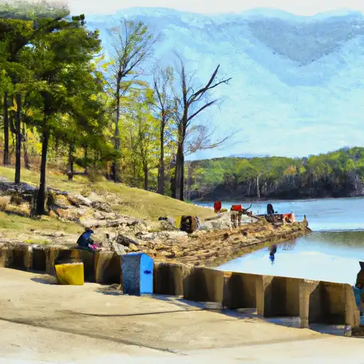


River runs
See all →


More reservoirs
See all →
About Sixmile Creek Wid Site 11
Where does the data for Sixmile Creek Wid Site 11 come from?
Structural and regulatory data come from the U.S. Army Corps of Engineers' National Inventory of Dams (NID). Weather forecast comes from NOAA / yr.no -- the same feed Snoflo's iOS app uses.
How often is the report updated?
NID structural data refreshes annually as the Corps publishes updated assessments. The weather forecast refreshes throughout the day.
What does the Significant hazard rating mean?
The Corps of Engineers' hazard potential classification grades probable consequences if the dam fails: High = probable loss of human life; Significant = no probable loss of human life but possible economic loss / environmental damage; Low = no probable loss of human life, only minor economic / environmental losses. See the Dam Data Reference card below for the full definitions.
What's "% of normal"?
The current storage value compared to the historical average storage on this calendar day. 100% = right on average; values above 100% mean above-normal storage (wet year); values below mean below-normal (dry year or drought).
Can I get alerts when storage crosses a threshold?
Yes -- alerts are managed in the Snoflo iOS app. Favorite this dam, set a threshold, and you'll get a push the moment conditions cross.
Dam data reference
Condition Assessment
- Satisfactory
- No existing or potential dam safety deficiencies are recognized. Acceptable performance is expected under all loading conditions (static, hydrologic, seismic) in accordance with the minimum applicable state or federal regulatory criteria or tolerable risk guidelines.
- Fair
- No existing dam safety deficiencies are recognized for normal operating conditions. Rare or extreme hydrologic and/or seismic events may result in a dam safety deficiency. Risk may be in the range to take further action.
- Poor
- A dam safety deficiency is recognized for normal operating conditions which may realistically occur. Remedial action is necessary. POOR may also be used when uncertainties exist as to critical analysis parameters which identify a potential dam safety deficiency.
- Unsatisfactory
- A dam safety deficiency is recognized that requires immediate or emergency remedial action for problem resolution.
- Not Rated
- The dam has not been inspected, is not under state or federal jurisdiction, or has been inspected but, for whatever reason, has not been rated.
Hazard Potential Classification
- High
- Dams assigned the high hazard potential classification are those where failure or mis-operation will probably cause loss of human life.
- Significant
- Dams assigned the significant hazard potential classification are those dams where failure or mis-operation results in no probable loss of human life but can cause economic loss, environmental damage, disruption of lifeline facilities, or impact other concerns. Significant hazard potential classification dams are often located in predominantly rural or agricultural areas but could be in areas with population and significant infrastructure.
- Low
- Dams assigned the low hazard potential classification are those where failure or mis-operation results in no probable loss of human life and low economic and/or environmental losses. Losses are principally limited to the owner's property.
- Undetermined
- Dams for which a downstream hazard potential has not been designated or is not provided.