Isabel Lake No. 2 dam

Isabel Lake No. 2
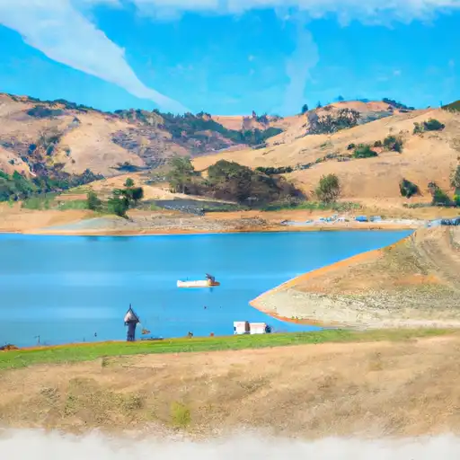
Isabel Lake No. 2 is a private water resource located in Sunol, California, primarily used for irrigation, recreation, and water supply. This earth dam stands at 18 feet in height with a hydraulic height of 13.7 feet, containing a storage capacity of 95 acre-feet. The dam, situated on Tr Isabel Creek, serves as a crucial component of the local water infrastructure, providing essential water resources for the surrounding area.
Managed by the California Department of Water Resources (DWR) under the Safety of Dams program, Isabel Lake No. 2 is regulated, permitted, inspected, and enforced by state agencies to ensure its safety and functionality. Despite its low hazard potential, the dam's condition assessment in September 2017 deemed it satisfactory, with a last inspection conducted in November 2020. This water supply structure plays a vital role in water management and conservation efforts within Santa Clara County, reflecting a commitment to sustainable resource utilization and environmental stewardship.
In the face of climate change impacts and increasing water scarcity concerns, the maintenance and proper functioning of dams like Isabel Lake No. 2 are essential for ensuring water security and resilience in the region. As a key player in the local water supply system, this dam underscores the importance of effective dam management practices and regulatory oversight to safeguard water resources for current and future generations. Its role in supporting irrigation, recreation, and water supply highlights the interconnectedness of water infrastructure with community well-being and underscores the need for continued investment in water resource management and climate adaptation strategies.
Plan around the weather
Same NOAA / yr.no feed Snoflo's iOS app uses. Watch the precipitation column on the meteogram -- rain on the basin upstream typically lifts inflow 24-72 hours later.
Next 5 days, hour by hour
Temperature line with weather symbols on top, snow + rain accumulation as columns, humidity as a dotted line.
5-day forecast table
Every 3 hours, broken out across temperature, snow, rain, humidity, and wind. Each cell is colour-coded relative to the column min/max.
| Time | Condition | Temp (°F) | Snow (in) | Rain (in) | Humidity (%) | Wind (mps) | Wind dir |
|---|---|---|---|---|---|---|---|
| Loading detailed forecast… | |||||||
15-day temperature & precipitation
Daily temperatures, snow, and rain projected over the next two weeks.
Nearby streamflow gauges
USGS streamgauges around Isabel Lake No. 2 -- inflows here typically show up in storage 24-72 hours later.
| Streamgauge | Discharge | View |
|---|---|---|
| Coyote C Bl Coyote Res Nr San Martin Ca | 5 cfs | → |
| Arroyo Hondo Nr San Jose Ca | 3 cfs | → |
| Coyote C Nr Gilroy Ca | · | → |
| Alameda C Ab Div Dam Nr Sunol Ca | 1 cfs | → |
| Alameda C Bl Div Dam Nr Sunol Ca | 0 cfs | → |
| Arroyo Valle Bl Lang Cn Nr Livermore Ca | · | → |


About Isabel Lake No. 2
Where does the data for Isabel Lake No. 2 come from?
Structural and regulatory data come from the U.S. Army Corps of Engineers' National Inventory of Dams (NID). Weather forecast comes from NOAA / yr.no -- the same feed Snoflo's iOS app uses.
How often is the report updated?
NID structural data refreshes annually as the Corps publishes updated assessments. The weather forecast refreshes throughout the day.
What does the Low hazard rating mean?
The Corps of Engineers' hazard potential classification grades probable consequences if the dam fails: High = probable loss of human life; Significant = no probable loss of human life but possible economic loss / environmental damage; Low = no probable loss of human life, only minor economic / environmental losses. See the Dam Data Reference card below for the full definitions.
What's "% of normal"?
The current storage value compared to the historical average storage on this calendar day. 100% = right on average; values above 100% mean above-normal storage (wet year); values below mean below-normal (dry year or drought).
Can I get alerts when storage crosses a threshold?
Yes -- alerts are managed in the Snoflo iOS app. Favorite this dam, set a threshold, and you'll get a push the moment conditions cross.
Dam data reference
Condition Assessment
- Satisfactory
- No existing or potential dam safety deficiencies are recognized. Acceptable performance is expected under all loading conditions (static, hydrologic, seismic) in accordance with the minimum applicable state or federal regulatory criteria or tolerable risk guidelines.
- Fair
- No existing dam safety deficiencies are recognized for normal operating conditions. Rare or extreme hydrologic and/or seismic events may result in a dam safety deficiency. Risk may be in the range to take further action.
- Poor
- A dam safety deficiency is recognized for normal operating conditions which may realistically occur. Remedial action is necessary. POOR may also be used when uncertainties exist as to critical analysis parameters which identify a potential dam safety deficiency.
- Unsatisfactory
- A dam safety deficiency is recognized that requires immediate or emergency remedial action for problem resolution.
- Not Rated
- The dam has not been inspected, is not under state or federal jurisdiction, or has been inspected but, for whatever reason, has not been rated.
Hazard Potential Classification
- High
- Dams assigned the high hazard potential classification are those where failure or mis-operation will probably cause loss of human life.
- Significant
- Dams assigned the significant hazard potential classification are those dams where failure or mis-operation results in no probable loss of human life but can cause economic loss, environmental damage, disruption of lifeline facilities, or impact other concerns. Significant hazard potential classification dams are often located in predominantly rural or agricultural areas but could be in areas with population and significant infrastructure.
- Low
- Dams assigned the low hazard potential classification are those where failure or mis-operation results in no probable loss of human life and low economic and/or environmental losses. Losses are principally limited to the owner's property.
- Undetermined
- Dams for which a downstream hazard potential has not been designated or is not provided.