INDIAN CREEK

Reservoir Levels Weather Hydrology


RESERVOIR CALIFORNIA

Indian Creek


May 3, 2024

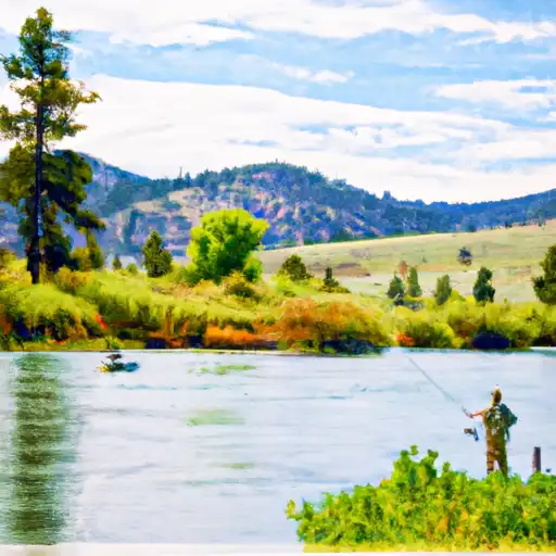
Indian Creek, located in Alpine, California, is a vital water resource managed by a public utility for various purposes including irrigation, recreation, and water supply. The dam, completed in 1967, stands at a height of 71 feet and has a hydraulic height of 63 feet. With a storage capacity of 3,160 acre-feet and a surface area of 160 acres, Indian Creek plays a crucial role in supporting the local ecosystem and communities.

The dam is under state jurisdiction and regulated by the Department of Water Resources for safety and inspection. Despite being classified as having a high hazard potential, the condition assessment in 2017 deemed it satisfactory. The last inspection in 2019 showed a regular inspection frequency of once per year. The dam's emergency action plan status and risk assessment measures are currently unknown, highlighting the need for continued monitoring and management to ensure the safety and sustainability of Indian Creek for both water resource and climate enthusiasts.

In the scenic town of Paynesville, Indian Creek stands as a testament to the delicate balance between water management and environmental conservation. With its rich history of serving as a water supply source and recreational spot, the dam at Indian Creek symbolizes the intersection of human needs and natural resources. As climate change impacts the availability and quality of water resources, Indian Creek serves as a reminder of the importance of sustainable practices and proactive risk management in safeguarding our precious water sources for future generations.


Year_Completed 1967
Dam_Height 71
River_Or_Stream Indian Creek
Dam_Length 1440
Primary_Dam_Type Earth
Surface_Area 160
Hydraulic_Height 63
Drainage_Area 3.06
Nid_Storage 3160
Hazard_Potential High
Nid_Height 71

Weather Outlook


16 Day Long Term Forecast

Seasonal Comparison


Historical Data


Area Boat Ramps

RAMP ROAD MONO COUNTY
East Walker Watershed, California
PROSSER LAKE RESERVOIR
Truckee Watershed, California
TOPAZ PARK ROAD DOUGLAS COUNTY
West Walker Watershed, Nevada
CAVE ROCK BOAT LAUNCH DOUGLAS COUNTY
Lake Tahoe Watershed, Nevada
GOLF COURSE OUTER TRAIL CARSON CITY
Middle Carson Watershed, Nevada
INDIAN CREEK CAMP GROUND DAY USE AREA
Upper Carson Watershed, California
AMADOR COUNTY
South Fork American Watershed, California
LAKESHORE BOULEVARD , 89452 NEVADA
Lake Tahoe Watershed, Nevada
SUMMIT LAKE TRAIL ALPINE COUNTY
Upper Carson Watershed, California
ICE HOUSE ROAD EL DORADO COUNTY
North Fork American Watershed, California

Rafting & Kayaking

STATE PARK TO CONFLUENCE WITH MIDDLE FORK FEATHER WSR
Middle Fork Feather Watershed, California
FRENCHMAN RESERVOIR TO NF BOUNDARY
Middle Fork Feather Watershed, Nevada
SEC 17, T25N, R14E TO CONFLUENCE WITH LAST CHANCE CREEK
East Branch North Fork Feather Watershed, California
CONFLUENCE WITH EAST AND WEST BRANCHES OF NELSON CREEK TO CONFLUENCE WITH MIDDLE FORK FEATHER WSR
Middle Fork Feather Watershed, California
HEADWATERS OF EAST FORK CANYON CREEK (SEC 13, T21N, R10E) TO CONFLUENCE WITH SOUTH FORK CANYON CREEK
Upper Yuba Watershed, California
SUSAN RIVER
Honey-Eagle Lakes Watershed, California
GOLD LAKE HIGHWAY TO NF BOUNDARY
Middle Fork Feather Watershed, California
WEST BRANCH NELSON CREEK HEADWATERS TO CONFLUENCE WITH NELSON CREEK
Middle Fork Feather Watershed, California
EAST BRANCH NELSON CREEK HEADWATERS TO CONFLUENCE WITH NELSON CREEK
Middle Fork Feather Watershed, California
CONFLUENCE WITH SQUAW QUEEN CREEK TO CONFLUENCE WITH RED CLOVER CREEK
East Branch North Fork Feather Watershed, California

Parks & Recreation


Mogul Park

Newlands Circle

Oxbow Park

Idlewild Park

Lundsford Park

Glendale Park

Rock Park

Sack Park

Rainbow Ridge Park

Portola City Park


ANGORA RIDGE
HANGMANS BRIDGE
Hangman's Bridge, located in the Upper Carson watershed in California, is a historical landmark that is shrouded in mystery and legend. The bridge is believed to have been built in ...
JUMBO GRADE
Jumbo Grade is a popular recreational area in the Truckee watershed in Nevada. It is located along the eastern slope of the Virginia Range and is easily accessible from Reno. ...
VIRGINIA CITY-COMSTOCK
The Virginia City Comstock is a historic mining town located in the Middle Carson watershed of Nevada. It was founded in 1859 after the discovery of silver and gold in ...
WILSON CANYON
Wilson Canyon is located in the West Walker watershed of Nevada and is known for its picturesque scenery and unique geological formations. The canyon is an ideal location for hiking ...
HERMIT VALLEY
DONNELL VISTA

Log Your Visit

When was your last visit to Indian Creek?

Add a Photo

How was it? How were conditions?

Rate the


Submit

Leave A Review

Indian Creek

Submit

Upload an Image

Indian Creek

Favorite Limit Reached