Steffen Brothers Reservoir Dam Dam

Steffen Brothers Reservoir Dam
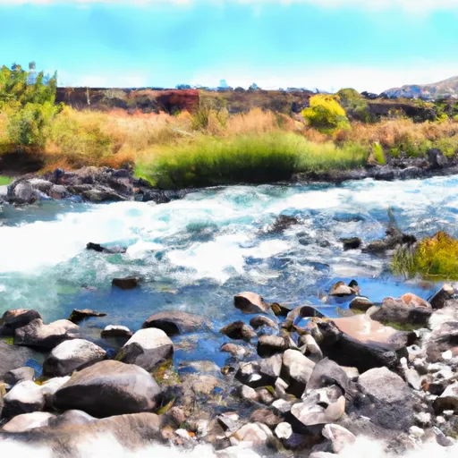
Located in Malaga, Washington, the Steffen Brothers Reservoir Dam stands as a testament to engineering and ingenuity. Completed in 1947, this private-owned structure serves multiple purposes, including irrigation and recreation, making it a vital resource for the local community. With a dam height of 15 feet and a storage capacity of 34 acre-feet, it not only provides water for irrigation but also creates a picturesque surface area of 4.2 acres for recreational activities.
Managed by the Washington Department of Ecology, the Steffen Brothers Reservoir Dam is subject to regular inspections, with a fair condition assessment and a high hazard potential. Despite its age, the dam continues to play a crucial role in water resource management in the area, showcasing the importance of proper maintenance and oversight. With its location along Little Stemilt Creek and proximity to the Seattle District, this dam is a key component of the water infrastructure in Chelan County.
Congressional District 08, represented by Kim Schrier (D), benefits from the presence of the Steffen Brothers Reservoir Dam, which not only provides water for irrigation but also offers a recreational oasis for locals and visitors alike. As climate change continues to impact water resources, structures like this dam become increasingly vital in managing and conserving water for both agricultural and recreational purposes. The ongoing maintenance and regulatory oversight ensure the safety and sustainability of this essential water resource in Washington state.
Plan around the weather
Same NOAA / yr.no feed Snoflo's iOS app uses. Watch the precipitation column on the meteogram -- rain on the basin upstream typically lifts inflow 24-72 hours later.
Next 5 days, hour by hour
Temperature line with weather symbols on top, snow + rain accumulation as columns, humidity as a dotted line.
5-day forecast table
Every 3 hours, broken out across temperature, snow, rain, humidity, and wind. Each cell is colour-coded relative to the column min/max.
| Time | Condition | Temp (°F) | Snow (in) | Rain (in) | Humidity (%) | Wind (mps) | Wind dir |
|---|---|---|---|---|---|---|---|
| Loading detailed forecast… | |||||||
15-day temperature & precipitation
Daily temperatures, snow, and rain projected over the next two weeks.
Nearby streamflow gauges
USGS streamgauges around Steffen Brothers Reservoir Dam -- inflows here typically show up in storage 24-72 hours later.
| Streamgauge | Discharge | View |
|---|---|---|
| Wenatchee River At Monitor | 1,190 cfs | → |
| Wenatchee River At Peshastin | 1,170 cfs | → |
| Icicle Creek Above Snow Creek Near Leavenworth | 222 cfs | → |
| Entiat River Near Entiat | 215 cfs | → |
| Yakima River At Umtanum | 3,680 cfs | → |
| Mad River At Ardenvoir | 24 cfs | → |
Make a day of it
Boat launches, lakeside camping, fishing access, and other reservoirs near Steffen Brothers Reservoir Dam.
Boat launches
See all →


Campgrounds
See all →


River runs
See all →


About Steffen Brothers Reservoir Dam
Where does the data for Steffen Brothers Reservoir Dam come from?
Structural and regulatory data come from the U.S. Army Corps of Engineers' National Inventory of Dams (NID). Weather forecast comes from NOAA / yr.no -- the same feed Snoflo's iOS app uses.
How often is the report updated?
NID structural data refreshes annually as the Corps publishes updated assessments. The weather forecast refreshes throughout the day.
What does the High hazard rating mean?
The Corps of Engineers' hazard potential classification grades probable consequences if the dam fails: High = probable loss of human life; Significant = no probable loss of human life but possible economic loss / environmental damage; Low = no probable loss of human life, only minor economic / environmental losses. See the Dam Data Reference card below for the full definitions.
What's "% of normal"?
The current storage value compared to the historical average storage on this calendar day. 100% = right on average; values above 100% mean above-normal storage (wet year); values below mean below-normal (dry year or drought).
Can I get alerts when storage crosses a threshold?
Yes -- alerts are managed in the Snoflo iOS app. Favorite this dam, set a threshold, and you'll get a push the moment conditions cross.
Dam data reference
Condition Assessment
- Satisfactory
- No existing or potential dam safety deficiencies are recognized. Acceptable performance is expected under all loading conditions (static, hydrologic, seismic) in accordance with the minimum applicable state or federal regulatory criteria or tolerable risk guidelines.
- Fair
- No existing dam safety deficiencies are recognized for normal operating conditions. Rare or extreme hydrologic and/or seismic events may result in a dam safety deficiency. Risk may be in the range to take further action.
- Poor
- A dam safety deficiency is recognized for normal operating conditions which may realistically occur. Remedial action is necessary. POOR may also be used when uncertainties exist as to critical analysis parameters which identify a potential dam safety deficiency.
- Unsatisfactory
- A dam safety deficiency is recognized that requires immediate or emergency remedial action for problem resolution.
- Not Rated
- The dam has not been inspected, is not under state or federal jurisdiction, or has been inspected but, for whatever reason, has not been rated.
Hazard Potential Classification
- High
- Dams assigned the high hazard potential classification are those where failure or mis-operation will probably cause loss of human life.
- Significant
- Dams assigned the significant hazard potential classification are those dams where failure or mis-operation results in no probable loss of human life but can cause economic loss, environmental damage, disruption of lifeline facilities, or impact other concerns. Significant hazard potential classification dams are often located in predominantly rural or agricultural areas but could be in areas with population and significant infrastructure.
- Low
- Dams assigned the low hazard potential classification are those where failure or mis-operation results in no probable loss of human life and low economic and/or environmental losses. Losses are principally limited to the owner's property.
- Undetermined
- Dams for which a downstream hazard potential has not been designated or is not provided.