Silver Fork Campground
Community Reviews
Been here? Share the conditions.
Reviews, ratings & photos are added in the free Snoflo iOS app — rate a spot, tag the conditions, and your visit is verified by location. Add or manage your reviews from the app.
Silver Fork
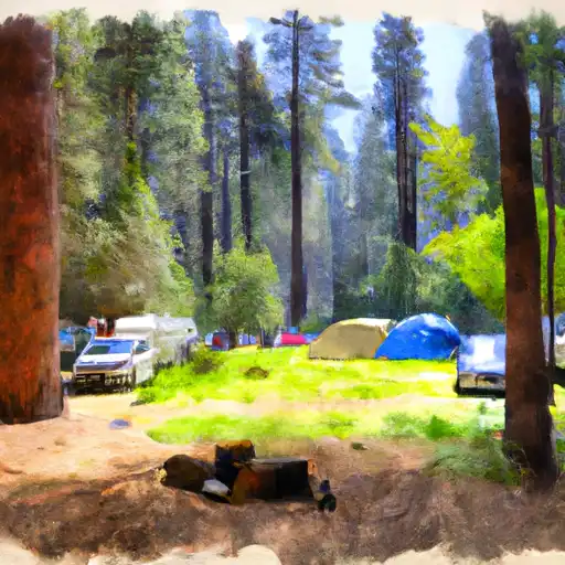
Reservations are accepted at Silver Fork camping area, allowing visitors to secure their spot in advance. This is particularly beneficial during peak seasons when the campground tends to be busy. It is recommended to make reservations well in advance to ensure availability during desired dates.
The best time to visit Silver Fork camping area is during the summer months, from June to September. During this time, the weather is generally pleasant, and campers can enjoy various outdoor activities such as hiking, fishing, and wildlife viewing. It is important to note that the campground is situated at an elevation of approximately 5,000 feet, so visitors should be prepared for cooler temperatures, especially during the evenings.
While camping at Silver Fork, campers should be cautious of the local wildlife, including bears and squirrels. It is essential to store food securely to prevent any unwanted encounters with animals. Additionally, campers should follow all camping guidelines, including proper disposal of garbage and respectful behavior towards fellow campers. With its amenities and beautiful surroundings, Silver Fork camping area provides an enjoyable camping experience for those visiting California.
What's on-site at Silver Fork
Key facilities Snoflo tracks for this campground. Confirm with the operator before booking -- amenities can change seasonally.
Plan your trip down to the hour
Same weather feed Snoflo's iOS app uses -- updated continuously from NOAA / yr.no.
Next 5 days, hour by hour
Temperature line with weather symbols on top, snow + rain accumulation as columns, humidity as a dotted line.
5-day forecast table
Every 3 hours, broken out across temperature, snow, rain, humidity, and wind. Each cell is colour-coded relative to the column min/max so trends jump out at a glance.
| Time | Condition | Temp (°F) | Snow (in) | Rain (in) | Humidity (%) | Wind (mps) | Wind dir |
|---|---|---|---|---|---|---|---|
| Loading detailed forecast… | |||||||
15-day temperature & precipitation
Daily temperatures, snow, and rain projected over the next two weeks. Hover any point for the full breakdown.
Other campgrounds in the area
Snoflo-tracked campsites within driving distance of Silver Fork, with reservations status.
| Campground | Reservations | Toilets | View |
|---|---|---|---|
| Silver Fork Campground | ✓ | ✗ | → |
| Harvey West Cabin | ✗ | ✗ | → |
| Ridge Camp | ✗ | ✗ | → |
| Silver Lake Campground West | ✗ | ✗ | → |
| Silver Lake Campground East | ✓ | ✗ | → |
Nearby streamflow
USGS streamgauges within reach of Silver Fork -- pulled live from the National Water Information System.
| Streamgauge | Discharge | View |
|---|---|---|
| Upper Truckee R At S Upper Truckee Rd Nr Meyers Ca | 4 cfs | → |
| Upper Truckee R At Hwy 50 Above Meyers Ca | 9 cfs | → |
| Up Truckee R A South Lake Tahoe Ca | 10 cfs | → |
| Trout C Nr Tahoe Valley Ca | 17 cfs | → |
| West Fork Carson River At Woodfords | 19 cfs | → |
| Eagle Rock Ck Nr Stateline | 1 cfs | → |
Nearby snow depths
NRCS SNOTEL stations within reach of Silver Fork -- relevant when planning a shoulder-season or alpine trip.
| SNOTEL station | Snowpack | 24h Snowfall | View |
|---|---|---|---|
| Nohrsc Silver Lake (Goes) | 33.4 in | 0.0 in | → |
| Alpha | 0.0 in | 0.0 in | → |
| Nohrsc Forni Ridge | 1.5 in | 0.0 in | → |
| Nohrsc Carson Pass | 0.0 in | 0.0 in | → |
| Carson Pass | 0.0 in | 0.0 in | → |
| Nohrsc Echo Peak | 0.0 in | 0.0 in | → |
Plan a longer trip
The closest parks, lakes, boat launches, and paddle runs so a camping night can grow into a full weekend.
Parks
- Wilderness Desolation
- Washoe Meadows State Park
- Lake Valley State Recreation Area
- Wilderness Mokelumne
- Dl Bliss State Park
- Emerald Bay State Park
Boat launches
- Silver Lake
- Kit Carson Resort
- Amador County
- Caples Lake Resort
- Bear River Lake Resort
- Ice House Reservoir
Fishing spots
Points of interest
- Big Hill
- Angora Ridge
- Nature Center And Observatory
- Leoni House
- Vikingsholm Castle;Vikingsholm
- Fannette Island Tea House
Paddle runs
- Headwatersa In Sec 18, T9n, R16e To Confluence With Van Horn Creek
- Headwater In Sec 29, T9n,R16e To Confluence With Cat Creek
- Headwaters In Sec 15,T10n, R17e To Confluence With Silver Fork Of American River
- State Highway 50 To 1/4 Mile North Of State Highway 50
- 1/4 Mile North Of State Highway 50 To Avalanche Lake
- Confluence With Cat Creek To One Mile East Of Pipi Campground
Camping essentials & Leave No Trace
- Pack it in, pack it out
- Take all trash, food scraps, and gear back with you to keep campsites clean and protect wildlife.
- Respect wildlife
- Observe animals from a distance, store food securely, and never feed wildlife to maintain natural behavior and safety.
- Know before you go
- Check weather, fire restrictions, trail conditions, and permit requirements to ensure a safe and well-planned trip.
- Minimize campfire impact
- Use established fire rings, keep fires small, fully extinguish them, or opt for a camp stove when fires are restricted.
- Leave what you find
- Preserve natural and cultural features by avoiding removal of plants, rocks, artifacts, or other elements of the environment.
Set push alerts in the Snoflo app
Save Silver Fork as a favorite, set a custom threshold (precipitation, snowpack, freezing temperatures), and the iOS app will push the moment conditions cross.
About Silver Fork
Can I make reservations at Silver Fork?
This campground does not appear to accept reservations -- it's typically first-come, first-served. Arrive early on summer weekends.
How fresh is the weather data on this page?
The hourly forecast updates throughout the day from the NOAA / yr.no public feeds. Streamflow data is pulled live from USGS streamgauges and snowpack from the NRCS SNOTEL network.
What's the best time of year to visit?
Use the 15-day temperature & precipitation outlook on this page to plan -- pick a window with comfortable temperatures and low precipitation. For longer trips, the 5-day hourly meteogram shows snow + rain accumulation hour-by-hour.
How do I get to Silver Fork?
Tap Directions in the hero above to open driving directions in Google Maps, or Open in map to center the Snoflo interactive map on the campground.
Can I get alerts when conditions change?
Yes -- alerts are managed through the Snoflo iOS app. Favorite this campground, set a threshold (temperature, snowpack, precipitation), and you'll get a push the moment it crosses.
Other campgrounds near here
Snoflo-tracked campgrounds within driving distance of Silver Fork.