Snow Lake To Hoover Wilderness Boundary river run
Community Reviews
Been here? Share the conditions.
Reviews, ratings & photos are added in the free Snoflo iOS app — rate a spot, tag the conditions, and your visit is verified by location. Add or manage your reviews from the app.
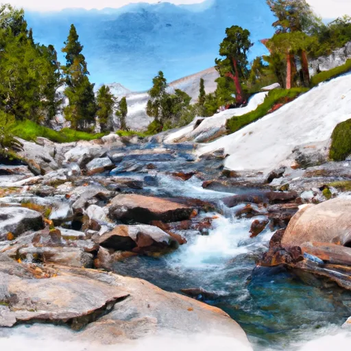
Snow Lake To Hoover Wilderness Boundary
The ideal streamflow range for this section of the river is between 300 and 600 cubic feet per second (cfs), which typically occurs in the spring and early summer months. The class rating for this section of the river is a Class IV-V, indicating that it is only suitable for experienced paddlers with strong whitewater skills.
The total segment mileage for this river run is approximately 7 miles, with a variety of challenging rapids and obstacles. Some of the most notable features include the Snow Lake Falls, the Rattlesnake Rapid, and the Big Drop. These features require expert maneuvering and quick reflexes to navigate successfully.
In addition to the challenging rapids, there are specific regulations to consider when planning a trip on this section of the river. Permits are required for all overnight trips, and campfires are prohibited above 10,000 feet elevation. Visitors are also required to pack out all trash and follow Leave No Trace principles to minimize impact on the environment.
Overall, the Whitewater River Run from Snow Lake to Hoover Wilderness Boundary is a thrilling and challenging adventure for experienced paddlers. However, it is important to carefully consider the ideal streamflow range, class rating, specific river rapids and obstacles, and regulations before embarking on this journey.
Plan your run down to the hour
Same weather feed Snoflo's iOS app uses -- updated continuously from NOAA / yr.no. Watch the precipitation column on the meteogram; rain ahead of a run typically lifts flows 12-48 hours later depending on the basin.
Next 5 days, hour by hour
Temperature line with weather symbols on top, snow + rain accumulation as columns, humidity as a dotted line.
5-day forecast table
Every 3 hours, broken out across temperature, snow, rain, humidity, and wind. Each cell is colour-coded relative to the column min/max.
| Time | Condition | Temp (°F) | Snow (in) | Rain (in) | Humidity (%) | Wind (mps) | Wind dir |
|---|---|---|---|---|---|---|---|
| Loading detailed forecast… | |||||||
15-day temperature & precipitation
Daily temperatures, snow, and rain projected over the next two weeks -- the upstream story that drives next week's flows.
Regional streamflow levels
USGS streamgauges around Snow Lake To Hoover Wilderness Boundary -- useful for spotting upstream pulses and gauging which tributary is contributing what.
| Streamgauge | Discharge | View |
|---|---|---|
| Robinson C At Twin Lks Outlet Nr Bridgeport | 101 cfs | → |
| Buckeye C Nr Bridgeport | 47 cfs | → |
| Green Creek Near Bridgeport | 22 cfs | → |
| Tuolumne R A Grand Cyn Of Tuolumne Ab Hetch Hetchy | 150 cfs | → |
| W Walker R Blw L Walker R Nr Coleville | 173 cfs | → |
| E Walker R Nr Bridgeport | 178 cfs | → |
Plan a longer trip
The closest boat launches, other paddle runs, and campgrounds so a day on the water can grow into a full weekend.
Other river runs
- Source (Tower Lake) Includes Kirkwood Creek, Cascade Creek And Tower Creek To Hoover Wilderness Boundary
- Headwaters, Includes East Fork And West Fork To Hoover Wilderness Boundary
- Hoover Wilderness Boundary To Humboldt-Toiyabe National Forest Boundary
- Headwaters To Hoover Wilderness Boundary
- Headwaters To Wilderness Boundary
Campgrounds
Fishing spots
Whitewater safety
- Check the flow before you run
- Use the linked-gauge card and Regional Flow panel above. Class ratings change with flow -- a Class III at low water can become Class IV+ at high water.
- Know your skill ceiling
- Pick runs comfortably below your ceiling. Cold-water and big-water runs raise the consequences of any mistake.
- Wear the right gear
- Helmet, PFD, drysuit / wetsuit when water is below 60°F. Throw bag, knife, and whistle on your person, not in the boat.
- Scout, set safety, and run with a team
- Scout new rapids on foot, set safety with throw bags above the consequence pool, and run with at least one other competent paddler.
- Respect the river
- Strainers, undercuts, low-head dams, and wood can kill at any class rating. When in doubt, portage.
Set push alerts in the Snoflo app
Save Snow Lake To Hoover Wilderness Boundary as a favorite, set a discharge threshold (e.g. "alert me when flow hits 600 cfs"), and the iOS app pushes the moment the linked gauge crosses.
About Snow Lake To Hoover Wilderness Boundary
What's the optimal flow for Snow Lake To Hoover Wilderness Boundary?
The optimal flow depends on the section and the craft. Check the Run Details panel for the linked gauge and current status.
How fresh is the cfs reading on this page?
The linked USGS streamgauge reports continuously (every 15 minutes); Snoflo refreshes throughout the day. Hover the streamflow sparkline to read individual datapoints.
What's the whitewater class?
See the Run Details panel for the class rating Snoflo tracks for this run. Class ratings change with flow -- a Class III at low water can become Class IV in high water.
Where do I put in / take out?
Tap Directions in the hero above to open driving directions to the put-in. For shuttle planning, check the Nearby Boat Launches panel and the river run operator's site.
Can I get alerts when flows hit the optimal range?
Yes -- alerts are managed in the Snoflo iOS app. Favorite this run, set a discharge threshold, and you'll get a push the moment the gauge crosses.
Other runs near here
Snoflo-tracked paddle runs within driving distance of Snow Lake To Hoover Wilderness Boundary.