Begins Near Muck Valley To Ends Two Miles From The Fall River Valley River Run
Community Reviews
Been here? Share the conditions.
Reviews, ratings & photos are added in the free Snoflo iOS app — rate a spot, tag the conditions, and your visit is verified by location. Add or manage your reviews from the app.
Begins Near Muck Valley To Ends Two Miles From The Fall River Valley
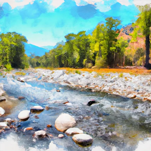
The segment mileage for this river run is approximately 8.5 miles. It is divided into three sections, with the first section being the most challenging. The rapids on this river run include the Meatgrinder, Trouble Maker, and Pipeline. These rapids are considered to be some of the most difficult on the river and require skilled maneuvering.
In addition to the rapids, there are also several obstacles on this river run, including rocks and fallen trees. It is important for paddlers to be aware of these obstacles and to navigate around them carefully.
There are specific regulations in place for this area, including a permit requirement for commercial outfitters and a limit on the number of permits issued per day. Paddlers are also required to wear personal flotation devices (PFDs) and to follow Leave No Trace principles while on the river.
Plan your run down to the hour
Same weather feed Snoflo's iOS app uses -- updated continuously from NOAA / yr.no. Watch the precipitation column on the meteogram; rain ahead of a run typically lifts flows 12-48 hours later depending on the basin.
Next 5 days, hour by hour
Temperature line with weather symbols on top, snow + rain accumulation as columns, humidity as a dotted line.
5-day forecast table
Every 3 hours, broken out across temperature, snow, rain, humidity, and wind. Each cell is colour-coded relative to the column min/max.
| Time | Condition | Temp (°F) | Snow (in) | Rain (in) | Humidity (%) | Wind (mps) | Wind dir |
|---|---|---|---|---|---|---|---|
| Loading detailed forecast… | |||||||
15-day temperature & precipitation
Daily temperatures, snow, and rain projected over the next two weeks -- the upstream story that drives next week's flows.
Regional streamflow levels
USGS streamgauges around Begins Near Muck Valley To Ends Two Miles From The Fall River Valley -- useful for spotting upstream pulses and gauging which tributary is contributing what.
| Streamgauge | Discharge | View |
|---|---|---|
| Pit R Bl Pit No 1 Ph Nr Fall River Mills Ca | 978 cfs | → |
| Hat C Nr Hat Creek Ca | 118 cfs | → |
| Burney C A Burney Falls Nr Burney Ca | 168 cfs | → |
| Pit R Nr Canby Ca | 2 cfs | → |
| Sf Pit R Nr Likely Ca | 133 cfs | → |
| Cow C Nr Millville Ca | 33 cfs | → |
Plan a longer trip
The closest boat launches, other paddle runs, and campgrounds so a day on the water can grow into a full weekend.
Boat launches
Other river runs
- Upper Pit River Canyon
- Lower Horse Creek Canyon
- Begins 2.5 Miles West Of Little Valley, California To Juncture With The Pit River.
- Begins Immediately Southwest Of Fall River Mills, Ca To It Flows Into Shasta Lake And The Sacramento River.
- Lower Pit River Canyon
Fishing spots
Whitewater safety
- Check the flow before you run
- Use the linked-gauge card and Regional Flow panel above. Class ratings change with flow -- a Class III at low water can become Class IV+ at high water.
- Know your skill ceiling
- Pick runs comfortably below your ceiling. Cold-water and big-water runs raise the consequences of any mistake.
- Wear the right gear
- Helmet, PFD, drysuit / wetsuit when water is below 60°F. Throw bag, knife, and whistle on your person, not in the boat.
- Scout, set safety, and run with a team
- Scout new rapids on foot, set safety with throw bags above the consequence pool, and run with at least one other competent paddler.
- Respect the river
- Strainers, undercuts, low-head dams, and wood can kill at any class rating. When in doubt, portage.
Set push alerts in the Snoflo app
Save Begins Near Muck Valley To Ends Two Miles From The Fall River Valley as a favorite, set a discharge threshold (e.g. "alert me when flow hits 600 cfs"), and the iOS app pushes the moment the linked gauge crosses.
About Begins Near Muck Valley To Ends Two Miles From The Fall River Valley
What's the optimal flow for Begins Near Muck Valley To Ends Two Miles From The Fall River Valley?
The optimal flow depends on the section and the craft. Check the Run Details panel for the linked gauge and current status.
How fresh is the cfs reading on this page?
The linked USGS streamgauge reports continuously (every 15 minutes); Snoflo refreshes throughout the day. Hover the streamflow sparkline to read individual datapoints.
What's the whitewater class?
See the Run Details panel for the class rating Snoflo tracks for this run. Class ratings change with flow -- a Class III at low water can become Class IV in high water.
Where do I put in / take out?
Tap Directions in the hero above to open driving directions to the put-in. For shuttle planning, check the Nearby Boat Launches panel and the river run operator's site.
Can I get alerts when flows hit the optimal range?
Yes -- alerts are managed in the Snoflo iOS app. Favorite this run, set a discharge threshold, and you'll get a push the moment the gauge crosses.
Other runs near here
Snoflo-tracked paddle runs within driving distance of Begins Near Muck Valley To Ends Two Miles From The Fall River Valley.