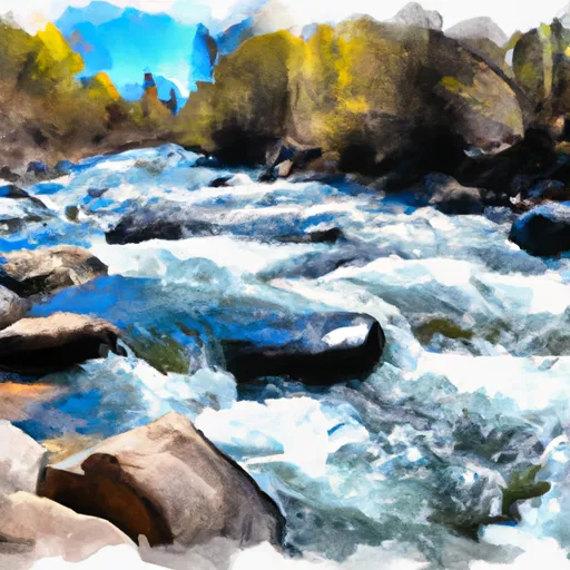
Roubideau Creek Segment 1 river run
Community Reviews
Been here? Share the conditions.
Reviews, ratings & photos are added in the free Snoflo iOS app — rate a spot, tag the conditions, and your visit is verified by location. Add or manage your reviews from the app.
Roubideau Creek Segment 1
One of the most prominent rapids on this segment is "The Box," a narrow canyon with tight turns and a technical drop that requires precise maneuvering. Other notable rapids include "Squeeze Play," "Double Drop," and "Classroom Falls." It is important to note that the Roubideau Creek Segment 1 is subject to flash floods during the rainy season, and paddlers should exercise caution and check the weather forecast before embarking on this run.
There are specific regulations to be aware of when paddling the Roubideau Creek Segment 1. Paddlers must obtain a permit from the Bureau of Land Management to access the creek. Additionally, motorized vehicles are not allowed on the creek, and camping is only permitted in designated areas. Paddlers should also be aware of the Leave No Trace principles and practice responsible stewardship of the surrounding environment.
Plan your run down to the hour
Same weather feed Snoflo's iOS app uses -- updated continuously from NOAA / yr.no. Watch the precipitation column on the meteogram; rain ahead of a run typically lifts flows 12-48 hours later depending on the basin.
Next 5 days, hour by hour
Temperature line with weather symbols on top, snow + rain accumulation as columns, humidity as a dotted line.
5-day forecast table
Every 3 hours, broken out across temperature, snow, rain, humidity, and wind. Each cell is colour-coded relative to the column min/max.
| Time | Condition | Temp (°F) | Snow (in) | Rain (in) | Humidity (%) | Wind (mps) | Wind dir |
|---|---|---|---|---|---|---|---|
| Loading detailed forecast… | |||||||
15-day temperature & precipitation
Daily temperatures, snow, and rain projected over the next two weeks -- the upstream story that drives next week's flows.
Regional streamflow levels
USGS streamgauges around Roubideau Creek Segment 1 -- useful for spotting upstream pulses and gauging which tributary is contributing what.
| Streamgauge | Discharge | View |
|---|---|---|
| Uncompahgre River At Delta | 109 cfs | → |
| Gunnison River At Delta | 599 cfs | → |
| San Miguel River At Brooks Bridge Near Nucla Co | 4 cfs | → |
| North Fk Gunnison River Above Mouth Nr Lazear | 52 cfs | → |
| Uncompahgre River At Colona | 107 cfs | → |
| Smith Fork Near Lazear | · | → |
Plan a longer trip
The closest boat launches, other paddle runs, and campgrounds so a day on the water can grow into a full weekend.
Boat launches
Other river runs
Campgrounds
- Escalante Potholes Rec Site
- Columbine Campground - Ouray Rd
- Columbine Campground
- Silesca Guard Station
- Iron Springs
- Iron Springs Campground
Fishing spots
- Twin Lakes Reservoir
- Sweitzer Lake
- Confluence Lake
- Gunnison River
- Chipeta Lakes Swa
- Fruitgrowers Reservoir
Whitewater safety
- Check the flow before you run
- Use the linked-gauge card and Regional Flow panel above. Class ratings change with flow -- a Class III at low water can become Class IV+ at high water.
- Know your skill ceiling
- Pick runs comfortably below your ceiling. Cold-water and big-water runs raise the consequences of any mistake.
- Wear the right gear
- Helmet, PFD, drysuit / wetsuit when water is below 60°F. Throw bag, knife, and whistle on your person, not in the boat.
- Scout, set safety, and run with a team
- Scout new rapids on foot, set safety with throw bags above the consequence pool, and run with at least one other competent paddler.
- Respect the river
- Strainers, undercuts, low-head dams, and wood can kill at any class rating. When in doubt, portage.
Set push alerts in the Snoflo app
Save Roubideau Creek Segment 1 as a favorite, set a discharge threshold (e.g. "alert me when flow hits 600 cfs"), and the iOS app pushes the moment the linked gauge crosses.
About Roubideau Creek Segment 1
What's the optimal flow for Roubideau Creek Segment 1?
The optimal flow depends on the section and the craft. Check the Run Details panel for the linked gauge and current status.
How fresh is the cfs reading on this page?
The linked USGS streamgauge reports continuously (every 15 minutes); Snoflo refreshes throughout the day. Hover the streamflow sparkline to read individual datapoints.
What's the whitewater class?
See the Run Details panel for the class rating Snoflo tracks for this run. Class ratings change with flow -- a Class III at low water can become Class IV in high water.
Where do I put in / take out?
Tap Directions in the hero above to open driving directions to the put-in. For shuttle planning, check the Nearby Boat Launches panel and the river run operator's site.
Can I get alerts when flows hit the optimal range?
Yes -- alerts are managed in the Snoflo iOS app. Favorite this run, set a discharge threshold, and you'll get a push the moment the gauge crosses.
Other runs near here
Snoflo-tracked paddle runs within driving distance of Roubideau Creek Segment 1.