South Fork Snake River River Run
Community Reviews
Been here? Share the conditions.
Reviews, ratings & photos are added in the free Snoflo iOS app — rate a spot, tag the conditions, and your visit is verified by location. Add or manage your reviews from the app.
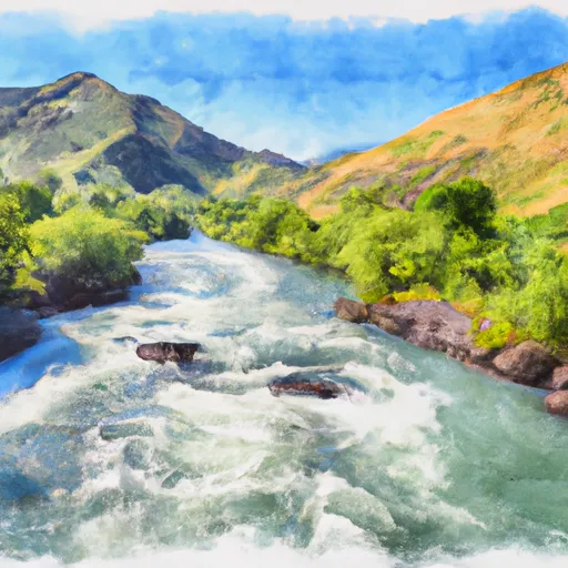
South Fork Snake River
Some of the most notable rapids on the South Fork Snake River include the Calamity, Wolf, and Cottonwood rapids. These rapids feature technical drops and steep chutes that require precise maneuvers and strong paddling skills. Other obstacles on the river include boulder gardens, tight channels, and log jams, which can make navigation challenging even for experienced paddlers.
There are several regulations that apply to the South Fork Snake River, including restrictions on camping and fires in certain areas. Additionally, all paddlers are required to wear a personal flotation device (PFD) at all times while on the river.
Overall, the South Fork Snake River is a challenging and rewarding whitewater river run that offers a range of obstacles and rapids for experienced paddlers. With its stunning scenery and rugged terrain, it is a must-visit destination for anyone looking to test their paddling skills in Idaho.
Plan your run down to the hour
Same weather feed Snoflo's iOS app uses -- updated continuously from NOAA / yr.no. Watch the precipitation column on the meteogram; rain ahead of a run typically lifts flows 12-48 hours later depending on the basin.
Next 5 days, hour by hour
Temperature line with weather symbols on top, snow + rain accumulation as columns, humidity as a dotted line.
5-day forecast table
Every 3 hours, broken out across temperature, snow, rain, humidity, and wind. Each cell is colour-coded relative to the column min/max.
| Time | Condition | Temp (°F) | Snow (in) | Rain (in) | Humidity (%) | Wind (mps) | Wind dir |
|---|---|---|---|---|---|---|---|
| Loading detailed forecast… | |||||||
15-day temperature & precipitation
Daily temperatures, snow, and rain projected over the next two weeks -- the upstream story that drives next week's flows.
Regional streamflow levels
USGS streamgauges around South Fork Snake River -- useful for spotting upstream pulses and gauging which tributary is contributing what.
| Streamgauge | Discharge | View |
|---|---|---|
| Snake River Nr Heise Id | 14,000 cfs | → |
| Dry Bed Nr Ririe Id | 2,710 cfs | → |
| Willow Creek Nr Ririe Id | 71 cfs | → |
| Sand Creek Ab Willow Creek Div Nr Ucon Id | 372 cfs | → |
| Willow Creek Bl Tex Creek Nr Ririe Id | 9 cfs | → |
| Willow Creek Floodway Channel Nr Ucon Id | 1 cfs | → |
Plan a longer trip
The closest boat launches, other paddle runs, and campgrounds so a day on the water can grow into a full weekend.
Boat launches
- Byington Boat Ramp
- Wolf Flats Recreation Area
- Heise Bridge Boat Access
- Bonneville County
- Twin Bridges
- East Lincoln Road Bonneville County
Other river runs
- Pine Creek To Riley Diversion
- Just West Of Crystal Lake To Trailhead
- Canyon Creek
- Tie Canyon To Targhee Nf Boundary
Whitewater safety
- Check the flow before you run
- Use the linked-gauge card and Regional Flow panel above. Class ratings change with flow -- a Class III at low water can become Class IV+ at high water.
- Know your skill ceiling
- Pick runs comfortably below your ceiling. Cold-water and big-water runs raise the consequences of any mistake.
- Wear the right gear
- Helmet, PFD, drysuit / wetsuit when water is below 60°F. Throw bag, knife, and whistle on your person, not in the boat.
- Scout, set safety, and run with a team
- Scout new rapids on foot, set safety with throw bags above the consequence pool, and run with at least one other competent paddler.
- Respect the river
- Strainers, undercuts, low-head dams, and wood can kill at any class rating. When in doubt, portage.
Set push alerts in the Snoflo app
Save South Fork Snake River as a favorite, set a discharge threshold (e.g. "alert me when flow hits 600 cfs"), and the iOS app pushes the moment the linked gauge crosses.
About South Fork Snake River
What's the optimal flow for South Fork Snake River?
The optimal flow depends on the section and the craft. Check the Run Details panel for the linked gauge and current status.
How fresh is the cfs reading on this page?
The linked USGS streamgauge reports continuously (every 15 minutes); Snoflo refreshes throughout the day. Hover the streamflow sparkline to read individual datapoints.
What's the whitewater class?
See the Run Details panel for the class rating Snoflo tracks for this run. Class ratings change with flow -- a Class III at low water can become Class IV in high water.
Where do I put in / take out?
Tap Directions in the hero above to open driving directions to the put-in. For shuttle planning, check the Nearby Boat Launches panel and the river run operator's site.
Can I get alerts when flows hit the optimal range?
Yes -- alerts are managed in the Snoflo iOS app. Favorite this run, set a discharge threshold, and you'll get a push the moment the gauge crosses.
Other runs near here
Snoflo-tracked paddle runs within driving distance of South Fork Snake River.