Cuttoff, Sec. 9, T18n, R27w To Sec. 34, T19n, R25w River Run
Community Reviews
Been here? Share the conditions.
Reviews, ratings & photos are added in the free Snoflo iOS app — rate a spot, tag the conditions, and your visit is verified by location. Add or manage your reviews from the app.
Cuttoff, Sec. 9, T18n, R27w To Sec. 34, T19n, R25w
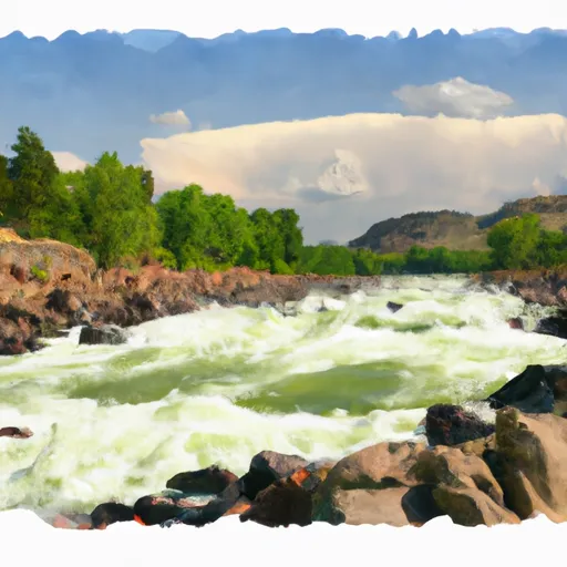
The river rapids and obstacles include "The Notch," a steep, narrow chute that requires expert maneuvering, and "The Jaws," a series of large boulders that create a challenging rapid. Other notable rapids include "Boulder Garden," "Kitchen Sink," and "Screaming Left Turn."
There are specific regulations for this area, including a requirement for all boaters to wear personal flotation devices (PFDs) at all times. Additionally, all boaters must carry a sound-producing device and a spare paddle. Camping is allowed along the river, but fires are prohibited. It is essential to obtain a permit before camping. The area is also subject to seasonal closures and restrictions due to weather and water conditions.
Overall, the Whitewater River Run Cuttoff offers a thrilling and challenging rafting experience for experienced boaters. It is essential to be aware of the specific regulations and to check current streamflow conditions before embarking on a trip down this section of the river.
Plan your run down to the hour
Same weather feed Snoflo's iOS app uses -- updated continuously from NOAA / yr.no. Watch the precipitation column on the meteogram; rain ahead of a run typically lifts flows 12-48 hours later depending on the basin.
Next 5 days, hour by hour
Temperature line with weather symbols on top, snow + rain accumulation as columns, humidity as a dotted line.
5-day forecast table
Every 3 hours, broken out across temperature, snow, rain, humidity, and wind. Each cell is colour-coded relative to the column min/max.
| Time | Condition | Temp (°F) | Snow (in) | Rain (in) | Humidity (%) | Wind (mps) | Wind dir |
|---|---|---|---|---|---|---|---|
| Loading detailed forecast… | |||||||
15-day temperature & precipitation
Daily temperatures, snow, and rain projected over the next two weeks -- the upstream story that drives next week's flows.
Regional streamflow levels
USGS streamgauges around Cuttoff, Sec. 9, T18n, R27w To Sec. 34, T19n, R25w -- useful for spotting upstream pulses and gauging which tributary is contributing what.
| Streamgauge | Discharge | View |
|---|---|---|
| Clark Fork Near Plains Mt | 12,900 cfs | → |
| Flathead River At Perma Mt | 9,240 cfs | → |
| Clark Fork At St. Regis Mt | 4,010 cfs | → |
| St. Regis River Near St. Regis | 117 cfs | → |
| Thompson River Near Thompson Falls Mt | 209 cfs | → |
| Prospect Creek At Thompson Falls Mt | 74 cfs | → |
Plan a longer trip
The closest boat launches, other paddle runs, and campgrounds so a day on the water can grow into a full weekend.
Other river runs
- Slowery, Sec. 15, T17n, R27w To Sec. 31, T18n. R28w
- Alberton Gorge (St. John To Forrest Grove)
- West Fork Fish Creek Headwaters, Sec. 6, T13n, R26w To Clearwater Crossing Trailhead, Sec. 6, T13n, R25w
- Cedar Log Creek Headwaters, Sec. 14, T12n, R26w To Mainstem, Sec. 19, T13n, R25w
- Middle Fork Indian Creek Headwaters, Sec. 14, T12n, R26w To Mainstem, Sec. 25, T12n, R26w
Campgrounds
- Cascade Campground
- Cascade Trailhead
- Muchwater Dispersed Campground And Recreation Area
- Peninsula Dispersed Campground And Recreation Area
- Rainbow Lake Campground
- Rainbow Lake North Campground
Fishing spots
Whitewater safety
- Check the flow before you run
- Use the linked-gauge card and Regional Flow panel above. Class ratings change with flow -- a Class III at low water can become Class IV+ at high water.
- Know your skill ceiling
- Pick runs comfortably below your ceiling. Cold-water and big-water runs raise the consequences of any mistake.
- Wear the right gear
- Helmet, PFD, drysuit / wetsuit when water is below 60°F. Throw bag, knife, and whistle on your person, not in the boat.
- Scout, set safety, and run with a team
- Scout new rapids on foot, set safety with throw bags above the consequence pool, and run with at least one other competent paddler.
- Respect the river
- Strainers, undercuts, low-head dams, and wood can kill at any class rating. When in doubt, portage.
Set push alerts in the Snoflo app
Save Cuttoff, Sec. 9, T18n, R27w To Sec. 34, T19n, R25w as a favorite, set a discharge threshold (e.g. "alert me when flow hits 600 cfs"), and the iOS app pushes the moment the linked gauge crosses.
About Cuttoff, Sec. 9, T18n, R27w To Sec. 34, T19n, R25w
What's the optimal flow for Cuttoff, Sec. 9, T18n, R27w To Sec. 34, T19n, R25w?
The optimal flow depends on the section and the craft. Check the Run Details panel for the linked gauge and current status.
How fresh is the cfs reading on this page?
The linked USGS streamgauge reports continuously (every 15 minutes); Snoflo refreshes throughout the day. Hover the streamflow sparkline to read individual datapoints.
What's the whitewater class?
See the Run Details panel for the class rating Snoflo tracks for this run. Class ratings change with flow -- a Class III at low water can become Class IV in high water.
Where do I put in / take out?
Tap Directions in the hero above to open driving directions to the put-in. For shuttle planning, check the Nearby Boat Launches panel and the river run operator's site.
Can I get alerts when flows hit the optimal range?
Yes -- alerts are managed in the Snoflo iOS app. Favorite this run, set a discharge threshold, and you'll get a push the moment the gauge crosses.
Other runs near here
Snoflo-tracked paddle runs within driving distance of Cuttoff, Sec. 9, T18n, R27w To Sec. 34, T19n, R25w.