Upper Bear Dam

Upper Bear Dam
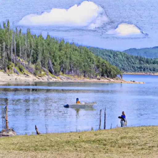
Upper Bear Dam, located in Syringa, Idaho, is a Federal-owned structure managed by the USDA Forest Service for recreational purposes. Built in 1910, this earth dam stands at a height of 13 feet and spans 390 feet along Bear Creek. The dam has a storage capacity of 82 acre-feet and covers an area of 18 acres, providing a serene environment for outdoor enthusiasts to enjoy various water activities.
Despite its low hazard potential, Upper Bear Dam is subject to regular inspections by the Forest Service to ensure its structural integrity and safety. The dam features an uncontrolled spillway and outlet gates, with a moderate risk assessment rating of 3. While the dam's condition assessment is currently listed as "Not Rated," it remains a vital resource for the local community and visitors alike, offering a picturesque setting for recreation and relaxation in the heart of Idaho's wilderness.
With its historical significance and natural beauty, Upper Bear Dam serves as a testament to the importance of water resource management and climate resilience. As climate change continues to impact water systems worldwide, the maintenance and preservation of structures like Upper Bear Dam are essential in safeguarding our environment and ensuring sustainable access to water for future generations of outdoor enthusiasts and nature lovers.
Plan around the weather
Same NOAA / yr.no feed Snoflo's iOS app uses. Watch the precipitation column on the meteogram -- rain on the basin upstream typically lifts inflow 24-72 hours later.
Next 5 days, hour by hour
Temperature line with weather symbols on top, snow + rain accumulation as columns, humidity as a dotted line.
5-day forecast table
Every 3 hours, broken out across temperature, snow, rain, humidity, and wind. Each cell is colour-coded relative to the column min/max.
| Time | Condition | Temp (°F) | Snow (in) | Rain (in) | Humidity (%) | Wind (mps) | Wind dir |
|---|---|---|---|---|---|---|---|
| Loading detailed forecast… | |||||||
15-day temperature & precipitation
Daily temperatures, snow, and rain projected over the next two weeks.
Nearby streamflow gauges
USGS streamgauges around Upper Bear Dam -- inflows here typically show up in storage 24-72 hours later.
| Streamgauge | Discharge | View |
|---|---|---|
| Bitterroot River Near Darby Mt | 411 cfs | → |
| West Fork Bitterroot River Nr Conner Mt | 135 cfs | → |
| Bitterroot River At Bell Crossing Nr Victor Mt | 308 cfs | → |
| Middle Fork Rock Cr Nr Philipsburg Mt | 110 cfs | → |
| Selway River Nr Lowell Id | 1,240 cfs | → |
| Lochsa River Nr Lowell Id | 914 cfs | → |
Make a day of it
Boat launches, lakeside camping, fishing access, and other reservoirs near Upper Bear Dam.
Boat launches
See all →


Campgrounds
See all →


Fishing spots
See all →


River runs
See all →


About Upper Bear Dam
Where does the data for Upper Bear Dam come from?
Structural and regulatory data come from the U.S. Army Corps of Engineers' National Inventory of Dams (NID). Weather forecast comes from NOAA / yr.no -- the same feed Snoflo's iOS app uses.
How often is the report updated?
NID structural data refreshes annually as the Corps publishes updated assessments. The weather forecast refreshes throughout the day.
What does the Low hazard rating mean?
The Corps of Engineers' hazard potential classification grades probable consequences if the dam fails: High = probable loss of human life; Significant = no probable loss of human life but possible economic loss / environmental damage; Low = no probable loss of human life, only minor economic / environmental losses. See the Dam Data Reference card below for the full definitions.
What's "% of normal"?
The current storage value compared to the historical average storage on this calendar day. 100% = right on average; values above 100% mean above-normal storage (wet year); values below mean below-normal (dry year or drought).
Can I get alerts when storage crosses a threshold?
Yes -- alerts are managed in the Snoflo iOS app. Favorite this dam, set a threshold, and you'll get a push the moment conditions cross.
Dam data reference
Condition Assessment
- Satisfactory
- No existing or potential dam safety deficiencies are recognized. Acceptable performance is expected under all loading conditions (static, hydrologic, seismic) in accordance with the minimum applicable state or federal regulatory criteria or tolerable risk guidelines.
- Fair
- No existing dam safety deficiencies are recognized for normal operating conditions. Rare or extreme hydrologic and/or seismic events may result in a dam safety deficiency. Risk may be in the range to take further action.
- Poor
- A dam safety deficiency is recognized for normal operating conditions which may realistically occur. Remedial action is necessary. POOR may also be used when uncertainties exist as to critical analysis parameters which identify a potential dam safety deficiency.
- Unsatisfactory
- A dam safety deficiency is recognized that requires immediate or emergency remedial action for problem resolution.
- Not Rated
- The dam has not been inspected, is not under state or federal jurisdiction, or has been inspected but, for whatever reason, has not been rated.
Hazard Potential Classification
- High
- Dams assigned the high hazard potential classification are those where failure or mis-operation will probably cause loss of human life.
- Significant
- Dams assigned the significant hazard potential classification are those dams where failure or mis-operation results in no probable loss of human life but can cause economic loss, environmental damage, disruption of lifeline facilities, or impact other concerns. Significant hazard potential classification dams are often located in predominantly rural or agricultural areas but could be in areas with population and significant infrastructure.
- Low
- Dams assigned the low hazard potential classification are those where failure or mis-operation results in no probable loss of human life and low economic and/or environmental losses. Losses are principally limited to the owner's property.
- Undetermined
- Dams for which a downstream hazard potential has not been designated or is not provided.