Town Bluff Dam

Town Bluff Dam
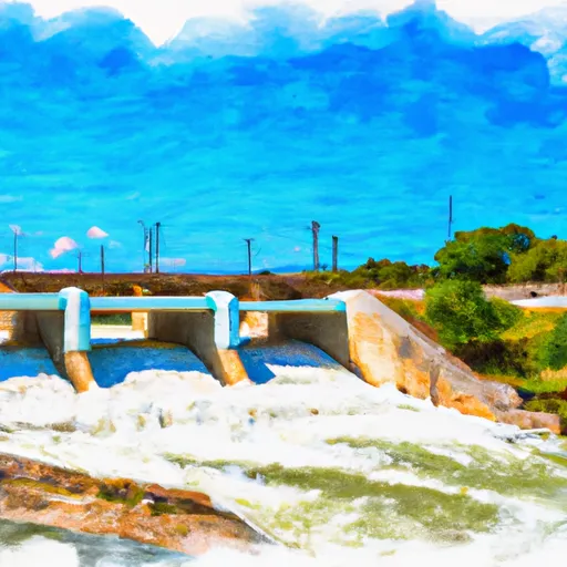
Located in Jasper, Texas, Town Bluff Dam, also known as B.A. Steinhagen Lake, is a federal-owned earthen dam built by the US Army Corps of Engineers in 1951. With a height of 43 feet and a length of 6698 feet, the dam serves multiple purposes including fish and wildlife habitat, hydroelectric power generation, recreation, and water supply. The dam's reservoir has a normal storage capacity of 67,000 acre-feet and a maximum storage of 218,200 acre-feet, covering a surface area of 14,700 acres and draining a watershed of 7573 acres along the Neches River.
Despite being classified as having a high hazard potential, Town Bluff Dam has a low risk of failure according to a risk assessment conducted by the USACE in 2014. The main risks identified include erosion through the dam's foundation during extreme flood events, potentially impacting downstream communities such as Evadale, Beaumont, and Rose City. To mitigate these risks, USACE has implemented various risk management measures, including conducting emergency exercises, updating the Emergency Action Plan, and maintaining a robust instrumentation and monitoring system to ensure the dam's integrity. The agency is also proactive in identifying and implementing interim risk reduction measures to safeguard public safety and reduce the likelihood of dam failure.
Plan around the weather
Same NOAA / yr.no feed Snoflo's iOS app uses. Watch the precipitation column on the meteogram -- rain on the basin upstream typically lifts inflow 24-72 hours later.
Next 5 days, hour by hour
Temperature line with weather symbols on top, snow + rain accumulation as columns, humidity as a dotted line.
5-day forecast table
Every 3 hours, broken out across temperature, snow, rain, humidity, and wind. Each cell is colour-coded relative to the column min/max.
| Time | Condition | Temp (°F) | Snow (in) | Rain (in) | Humidity (%) | Wind (mps) | Wind dir |
|---|---|---|---|---|---|---|---|
| Loading detailed forecast… | |||||||
15-day temperature & precipitation
Daily temperatures, snow, and rain projected over the next two weeks.
Nearby streamflow gauges
USGS streamgauges around Town Bluff Dam -- inflows here typically show up in storage 24-72 hours later.
| Streamgauge | Discharge | View |
|---|---|---|
| Neches Rv Nr Town Bluff | 1,390 cfs | → |
| Neches Rv Nr Rockland | 395 cfs | → |
| Big Cow Ck Nr Newton | 41 cfs | → |
| Village Ck Nr Kountze | 243 cfs | → |
| Neches Rv At Evadale | 1,980 cfs | → |
| Sabine Rv Nr Bon Wier | 3,260 cfs | → |


About Town Bluff Dam
Where does the data for Town Bluff Dam come from?
Structural and regulatory data come from the U.S. Army Corps of Engineers' National Inventory of Dams (NID). Weather forecast comes from NOAA / yr.no -- the same feed Snoflo's iOS app uses.
How often is the report updated?
NID structural data refreshes annually as the Corps publishes updated assessments. The weather forecast refreshes throughout the day.
What does the High hazard rating mean?
The Corps of Engineers' hazard potential classification grades probable consequences if the dam fails: High = probable loss of human life; Significant = no probable loss of human life but possible economic loss / environmental damage; Low = no probable loss of human life, only minor economic / environmental losses. See the Dam Data Reference card below for the full definitions.
What's "% of normal"?
The current storage value compared to the historical average storage on this calendar day. 100% = right on average; values above 100% mean above-normal storage (wet year); values below mean below-normal (dry year or drought).
Can I get alerts when storage crosses a threshold?
Yes -- alerts are managed in the Snoflo iOS app. Favorite this dam, set a threshold, and you'll get a push the moment conditions cross.
Dam data reference
Condition Assessment
- Satisfactory
- No existing or potential dam safety deficiencies are recognized. Acceptable performance is expected under all loading conditions (static, hydrologic, seismic) in accordance with the minimum applicable state or federal regulatory criteria or tolerable risk guidelines.
- Fair
- No existing dam safety deficiencies are recognized for normal operating conditions. Rare or extreme hydrologic and/or seismic events may result in a dam safety deficiency. Risk may be in the range to take further action.
- Poor
- A dam safety deficiency is recognized for normal operating conditions which may realistically occur. Remedial action is necessary. POOR may also be used when uncertainties exist as to critical analysis parameters which identify a potential dam safety deficiency.
- Unsatisfactory
- A dam safety deficiency is recognized that requires immediate or emergency remedial action for problem resolution.
- Not Rated
- The dam has not been inspected, is not under state or federal jurisdiction, or has been inspected but, for whatever reason, has not been rated.
Hazard Potential Classification
- High
- Dams assigned the high hazard potential classification are those where failure or mis-operation will probably cause loss of human life.
- Significant
- Dams assigned the significant hazard potential classification are those dams where failure or mis-operation results in no probable loss of human life but can cause economic loss, environmental damage, disruption of lifeline facilities, or impact other concerns. Significant hazard potential classification dams are often located in predominantly rural or agricultural areas but could be in areas with population and significant infrastructure.
- Low
- Dams assigned the low hazard potential classification are those where failure or mis-operation results in no probable loss of human life and low economic and/or environmental losses. Losses are principally limited to the owner's property.
- Undetermined
- Dams for which a downstream hazard potential has not been designated or is not provided.