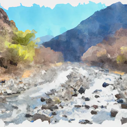
Confluence Of Tributaries In Sec 6 Near Black Mtn. To Confluence With Blind Horse Creek River Run
Community Reviews
Been here? Share the conditions.
Reviews, ratings & photos are added in the free Snoflo iOS app — rate a spot, tag the conditions, and your visit is verified by location. Add or manage your reviews from the app.
Confluence Of Tributaries In Sec 6 Near Black Mtn. To Confluence With Blind Horse Creek
The segment mileage of this river run is approximately 10 miles. Starting at the confluence of tributaries in Section 6 near Black Mtn, the river flows through steep granite canyons and dense forest before reaching the confluence with Blind Horse Creek.
There are several specific rapids and obstacles to navigate along this river run, including the infamous "Nugget Rapid" and "Frog Jump Rapid." These rapids are known for their technical difficulty and challenging features, such as steep drops, tight chutes, and powerful hydraulics.
There are specific regulations and guidelines that apply to this area, including the requirement for all boaters to wear personal flotation devices (PFDs) and to carry a whistle and a throw bag at all times. Additionally, there are restrictions on the use of motorized boats and a limit on the number of commercial outfitters allowed to operate in this section of the river.
Overall, the Whitewater River run from Confluence of Tributaries in Sec 6 Near Black Mtn. to Confluence With Blind Horse Creek offers a challenging and rewarding experience for experienced whitewater boaters. It is important to check current streamflow conditions and to follow all regulations and guidelines to ensure a safe and enjoyable outing.
Plan your run down to the hour
Same weather feed Snoflo's iOS app uses -- updated continuously from NOAA / yr.no. Watch the precipitation column on the meteogram; rain ahead of a run typically lifts flows 12-48 hours later depending on the basin.
Next 5 days, hour by hour
Temperature line with weather symbols on top, snow + rain accumulation as columns, humidity as a dotted line.
5-day forecast table
Every 3 hours, broken out across temperature, snow, rain, humidity, and wind. Each cell is colour-coded relative to the column min/max.
| Time | Condition | Temp (°F) | Snow (in) | Rain (in) | Humidity (%) | Wind (mps) | Wind dir |
|---|---|---|---|---|---|---|---|
| Loading detailed forecast… | |||||||
15-day temperature & precipitation
Daily temperatures, snow, and rain projected over the next two weeks -- the upstream story that drives next week's flows.
Regional streamflow levels
USGS streamgauges around Confluence Of Tributaries In Sec 6 Near Black Mtn. To Confluence With Blind Horse Creek -- useful for spotting upstream pulses and gauging which tributary is contributing what.
| Streamgauge | Discharge | View |
|---|---|---|
| Trinity R Ab Coffee C Nr Trinity Ctr Ca | 26 cfs | → |
| Nf Trinity R A Helena Ca | 47 cfs | → |
| Trinity R Ab Nf Trinity R Nr Helena Ca | 455 cfs | → |
| Trinity R A Junction City Ca | 494 cfs | → |
| Rush C Nr Lewiston Ca | 2 cfs | → |
| Trinity R A Lewiston Ca | 450 cfs | → |
Plan a longer trip
The closest boat launches, other paddle runs, and campgrounds so a day on the water can grow into a full weekend.
Boat launches
- Matthews Creek River Access
- Methodist Creek River Access
- Jack Ass Creek River Access
- Red Bank River Access
- Saw Pit Flat River Access
Other river runs
- Confluence With Blind Horse Creek To Cecilville Bridge
- Confluence With Sixmile Creek To Confluence With South Fork Salmon River
- Headwaters In Sw 1/4, Sec 24, T8n, R12w To Trinity Wsr (At Hobo Gulch Trailhead And Campground)
- Headwaters At Outlet Of Lower Canyon Creek Lake To Canyon Creek Trailhead At Ripstein Canyon Creek Trailhead At Ripstein
- Scott District Boundary To Confluence With Sixmile Creek
Campgrounds
Fishing spots
Whitewater safety
- Check the flow before you run
- Use the linked-gauge card and Regional Flow panel above. Class ratings change with flow -- a Class III at low water can become Class IV+ at high water.
- Know your skill ceiling
- Pick runs comfortably below your ceiling. Cold-water and big-water runs raise the consequences of any mistake.
- Wear the right gear
- Helmet, PFD, drysuit / wetsuit when water is below 60°F. Throw bag, knife, and whistle on your person, not in the boat.
- Scout, set safety, and run with a team
- Scout new rapids on foot, set safety with throw bags above the consequence pool, and run with at least one other competent paddler.
- Respect the river
- Strainers, undercuts, low-head dams, and wood can kill at any class rating. When in doubt, portage.
Set push alerts in the Snoflo app
Save Confluence Of Tributaries In Sec 6 Near Black Mtn. To Confluence With Blind Horse Creek as a favorite, set a discharge threshold (e.g. "alert me when flow hits 600 cfs"), and the iOS app pushes the moment the linked gauge crosses.
About Confluence Of Tributaries In Sec 6 Near Black Mtn. To Confluence With Blind Horse Creek
What's the optimal flow for Confluence Of Tributaries In Sec 6 Near Black Mtn. To Confluence With Blind Horse Creek?
The optimal flow depends on the section and the craft. Check the Run Details panel for the linked gauge and current status.
How fresh is the cfs reading on this page?
The linked USGS streamgauge reports continuously (every 15 minutes); Snoflo refreshes throughout the day. Hover the streamflow sparkline to read individual datapoints.
What's the whitewater class?
See the Run Details panel for the class rating Snoflo tracks for this run. Class ratings change with flow -- a Class III at low water can become Class IV in high water.
Where do I put in / take out?
Tap Directions in the hero above to open driving directions to the put-in. For shuttle planning, check the Nearby Boat Launches panel and the river run operator's site.
Can I get alerts when flows hit the optimal range?
Yes -- alerts are managed in the Snoflo iOS app. Favorite this run, set a discharge threshold, and you'll get a push the moment the gauge crosses.
Other runs near here
Snoflo-tracked paddle runs within driving distance of Confluence Of Tributaries In Sec 6 Near Black Mtn. To Confluence With Blind Horse Creek.