Bear Creek River Run
Community Reviews
Been here? Share the conditions.
Reviews, ratings & photos are added in the free Snoflo iOS app — rate a spot, tag the conditions, and your visit is verified by location. Add or manage your reviews from the app.
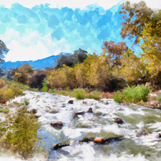
Bear Creek
The class rating for Bear Creek ranges from class III to class V, depending on the segment of the river being run. The upper segment is rated at class III, while the lower segment is rated at class V due to the presence of multiple rapids and obstacles.
The total segment mileage for Bear Creek is approximately 10 miles, with the upper segment being 3 miles and the lower segment being 7 miles. The upper segment is characterized by long pools and scenic views, while the lower segment is more technical and challenging, with tight channels and steep drops.
Some of the specific rapids and obstacles on Bear Creek include The Wall, The S-Turn, The Slot, and The Notch, which require advanced paddling skills to navigate safely.
There are specific regulations in place for the area, including a permit system and a limit on the number of daily permits issued. Additionally, all paddlers must wear a helmet and a personal flotation device at all times while on the river.
Plan your run down to the hour
Same weather feed Snoflo's iOS app uses -- updated continuously from NOAA / yr.no. Watch the precipitation column on the meteogram; rain ahead of a run typically lifts flows 12-48 hours later depending on the basin.
Next 5 days, hour by hour
Temperature line with weather symbols on top, snow + rain accumulation as columns, humidity as a dotted line.
5-day forecast table
Every 3 hours, broken out across temperature, snow, rain, humidity, and wind. Each cell is colour-coded relative to the column min/max.
| Time | Condition | Temp (°F) | Snow (in) | Rain (in) | Humidity (%) | Wind (mps) | Wind dir |
|---|---|---|---|---|---|---|---|
| Loading detailed forecast… | |||||||
15-day temperature & precipitation
Daily temperatures, snow, and rain projected over the next two weeks -- the upstream story that drives next week's flows.
Regional streamflow levels
USGS streamgauges around Bear Creek -- useful for spotting upstream pulses and gauging which tributary is contributing what.
| Streamgauge | Discharge | View |
|---|---|---|
| Cow C Nr Millville Ca | 34 cfs | → |
| Battle C Bl Coleman Fish Hatchery Nr Cottonwood Ca | 245 cfs | → |
| Cottonwood C Nr Cottonwood Ca | 64 cfs | → |
| Sacramento R Ab Bend Bridge Nr Red Bluff Ca | 13,300 cfs | → |
| Anderson-Cottonwood Id Cn At Sharon St Redding Ca | 260 cfs | → |
| Sacramento R A Keswick Ca | 13,200 cfs | → |
Plan a longer trip
The closest boat launches, other paddle runs, and campgrounds so a day on the water can grow into a full weekend.
Boat launches
- Balls Ferry Fishing Access
- Jelly's Ferry
- Jellys Ferry
- South Bonnyview Boat Launch
- Mccumber Reservoir
- Park Marina Drive 2525, Redding
Campgrounds
- Living Springs Campground
- Reading Island
- Mt. Lassen / Shingletown Koa Holiday
- Camping World
- Massacre Flat Primitive Camping Area
- Massacre Flat
Fishing spots
Whitewater safety
- Check the flow before you run
- Use the linked-gauge card and Regional Flow panel above. Class ratings change with flow -- a Class III at low water can become Class IV+ at high water.
- Know your skill ceiling
- Pick runs comfortably below your ceiling. Cold-water and big-water runs raise the consequences of any mistake.
- Wear the right gear
- Helmet, PFD, drysuit / wetsuit when water is below 60°F. Throw bag, knife, and whistle on your person, not in the boat.
- Scout, set safety, and run with a team
- Scout new rapids on foot, set safety with throw bags above the consequence pool, and run with at least one other competent paddler.
- Respect the river
- Strainers, undercuts, low-head dams, and wood can kill at any class rating. When in doubt, portage.
Set push alerts in the Snoflo app
Save Bear Creek as a favorite, set a discharge threshold (e.g. "alert me when flow hits 600 cfs"), and the iOS app pushes the moment the linked gauge crosses.
About Bear Creek
What's the optimal flow for Bear Creek?
The optimal flow depends on the section and the craft. Check the Run Details panel for the linked gauge and current status.
How fresh is the cfs reading on this page?
The linked USGS streamgauge reports continuously (every 15 minutes); Snoflo refreshes throughout the day. Hover the streamflow sparkline to read individual datapoints.
What's the whitewater class?
See the Run Details panel for the class rating Snoflo tracks for this run. Class ratings change with flow -- a Class III at low water can become Class IV in high water.
Where do I put in / take out?
Tap Directions in the hero above to open driving directions to the put-in. For shuttle planning, check the Nearby Boat Launches panel and the river run operator's site.
Can I get alerts when flows hit the optimal range?
Yes -- alerts are managed in the Snoflo iOS app. Favorite this run, set a discharge threshold, and you'll get a push the moment the gauge crosses.
Other runs near here
Snoflo-tracked paddle runs within driving distance of Bear Creek.