Meadow Lake Dam

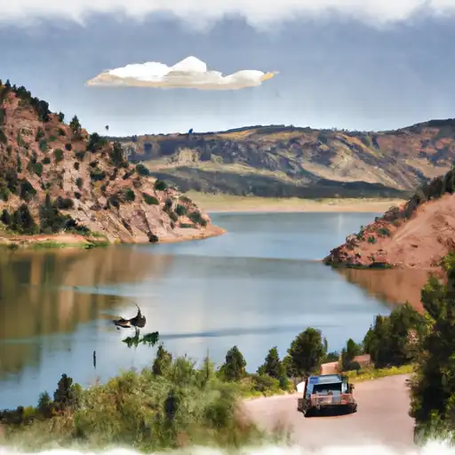
Meadow Lake
Meadow Lake, located in Mineral County, Colorado, is a privately owned reservoir primarily used for recreation. Built in 1940, this earth dam structure stands at 10 feet high with a length of 1980 feet, offering a maximum storage capacity of 261 acre-feet. The lake covers a surface area of 31 acres and is fed by Middle Creek, providing a serene environment for fishing, wildlife observation, and irrigation purposes.
Despite its low hazard potential, Meadow Lake presents a high risk assessment level due to its outdated inspection records and lack of emergency action plan preparation. The dam has not been rated for its current condition, and the last inspection was conducted in 1992. While the reservoir serves as a popular recreational spot in the area, there is a need for improved risk management measures to ensure the safety and sustainability of the water resource.
Water resource and climate enthusiasts visiting Meadow Lake in South Fork, Colorado, may enjoy its tranquil surroundings and diverse wildlife. With its picturesque setting and potential for outdoor activities, the lake serves as a vital water source for the local community while also offering a recreational haven for visitors. However, there is a pressing need for updated inspections, emergency preparedness, and risk management strategies to safeguard the dam and ensure the continued enjoyment of Meadow Lake for generations to come.
Plan around the weather
Same NOAA / yr.no feed Snoflo's iOS app uses. Watch the precipitation column on the meteogram -- rain on the basin upstream typically lifts inflow 24-72 hours later.
Next 5 days, hour by hour
Temperature line with weather symbols on top, snow + rain accumulation as columns, humidity as a dotted line.
5-day forecast table
Every 3 hours, broken out across temperature, snow, rain, humidity, and wind. Each cell is colour-coded relative to the column min/max.
| Time | Condition | Temp (°F) | Snow (in) | Rain (in) | Humidity (%) | Wind (mps) | Wind dir |
|---|---|---|---|---|---|---|---|
| Loading detailed forecast… | |||||||
15-day temperature & precipitation
Daily temperatures, snow, and rain projected over the next two weeks.
Nearby streamflow gauges
USGS streamgauges around Meadow Lake -- inflows here typically show up in storage 24-72 hours later.
| Streamgauge | Discharge | View |
|---|---|---|
| Goose Creek At Wagonwheel Gap | 13 cfs | → |
| Rio Grande At Wagon Wheel Gap | 167 cfs | → |
| Rio Grande At Thirtymile Bridge | 81 cfs | → |
| North Clear Creek Bl Continental Reservoir | 6 cfs | → |
| South Fork Rio Grande At South Fork | 45 cfs | → |
| Lake Fork Blw Lake San Cristobal Nr Lake City | 38 cfs | → |
Make a day of it
Boat launches, lakeside camping, fishing access, and other reservoirs near Meadow Lake.
Boat launches
See all →


Campgrounds
See all →


Fishing spots
See all →


River runs
See all →


About Meadow Lake
Where does the data for Meadow Lake come from?
Structural and regulatory data come from the U.S. Army Corps of Engineers' National Inventory of Dams (NID). Weather forecast comes from NOAA / yr.no -- the same feed Snoflo's iOS app uses.
How often is the report updated?
NID structural data refreshes annually as the Corps publishes updated assessments. The weather forecast refreshes throughout the day.
What does the Low hazard rating mean?
The Corps of Engineers' hazard potential classification grades probable consequences if the dam fails: High = probable loss of human life; Significant = no probable loss of human life but possible economic loss / environmental damage; Low = no probable loss of human life, only minor economic / environmental losses. See the Dam Data Reference card below for the full definitions.
What's "% of normal"?
The current storage value compared to the historical average storage on this calendar day. 100% = right on average; values above 100% mean above-normal storage (wet year); values below mean below-normal (dry year or drought).
Can I get alerts when storage crosses a threshold?
Yes -- alerts are managed in the Snoflo iOS app. Favorite this dam, set a threshold, and you'll get a push the moment conditions cross.
Dam data reference
Condition Assessment
- Satisfactory
- No existing or potential dam safety deficiencies are recognized. Acceptable performance is expected under all loading conditions (static, hydrologic, seismic) in accordance with the minimum applicable state or federal regulatory criteria or tolerable risk guidelines.
- Fair
- No existing dam safety deficiencies are recognized for normal operating conditions. Rare or extreme hydrologic and/or seismic events may result in a dam safety deficiency. Risk may be in the range to take further action.
- Poor
- A dam safety deficiency is recognized for normal operating conditions which may realistically occur. Remedial action is necessary. POOR may also be used when uncertainties exist as to critical analysis parameters which identify a potential dam safety deficiency.
- Unsatisfactory
- A dam safety deficiency is recognized that requires immediate or emergency remedial action for problem resolution.
- Not Rated
- The dam has not been inspected, is not under state or federal jurisdiction, or has been inspected but, for whatever reason, has not been rated.
Hazard Potential Classification
- High
- Dams assigned the high hazard potential classification are those where failure or mis-operation will probably cause loss of human life.
- Significant
- Dams assigned the significant hazard potential classification are those dams where failure or mis-operation results in no probable loss of human life but can cause economic loss, environmental damage, disruption of lifeline facilities, or impact other concerns. Significant hazard potential classification dams are often located in predominantly rural or agricultural areas but could be in areas with population and significant infrastructure.
- Low
- Dams assigned the low hazard potential classification are those where failure or mis-operation results in no probable loss of human life and low economic and/or environmental losses. Losses are principally limited to the owner's property.
- Undetermined
- Dams for which a downstream hazard potential has not been designated or is not provided.