


Bath County P S Middle Sediment Dam Reservoir Report
Last Updated: May 1, 2026
°F
°F
mph
Wind
%
Humidity
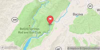
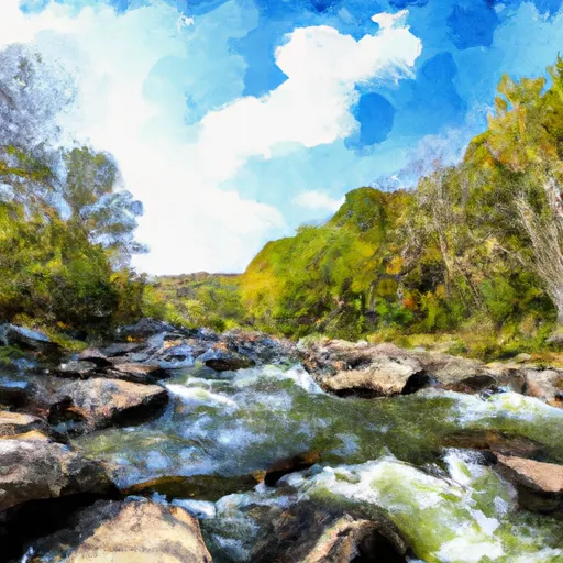
The Bath County P S Middle Sediment Dam, also known as Sediment Dam #2, is a rockfill dam located in Bath County, Virginia.
Summary
Completed in 1984, this dam stands at a height of 26 feet and stretches 218 feet in length, with a storage capacity of 21.8 acre-feet. Situated on the Little Back Creek in Mountain Grove, this dam serves a primary purpose as an erosion control measure, with a low hazard potential and a very high risk assessment rating.
Managed by a public utility, this dam is under the oversight of the Federal Energy Regulatory Commission (FERC) for inspections and regulatory compliance. While not state-regulated, it is designed to handle controlled spillway situations, with a drainage area of 2.6 square miles. Despite its limited surface area of 9 acres, the Bath County P S Middle Sediment Dam serves a critical role in managing water resources and protecting the surrounding environment from potential sediment runoff.
With a designated inspection frequency and emergency action plan in place, this dam plays a crucial role in mitigating risks and ensuring public safety in the event of a potential breach. Water resource and climate enthusiasts can appreciate the intricate design and functionality of the Bath County P S Middle Sediment Dam as a vital infrastructure component in managing water flow and sediment control in Bath County, Virginia.
Regional Streamflow Levels
15-Day Long Term Forecast
Year Completed |
1984 |
Dam Length |
218 |
Dam Height |
26 |
River Or Stream |
Little Back Creek |
Primary Dam Type |
Rockfill |
Surface Area |
9 |
Hydraulic Height |
26 |
Drainage Area |
2.6 |
Nid Storage |
21.8 |
Structural Height |
26 |
Hazard Potential |
Low |
Nid Height |
26 |
Seasonal Comparison
5-Day Hourly Forecast Detail
Dam Data Reference
Condition Assessment
SatisfactoryNo existing or potential dam safety deficiencies are recognized. Acceptable performance is expected under all loading conditions (static, hydrologic, seismic) in accordance with the minimum applicable state or federal regulatory criteria or tolerable risk guidelines.
Fair
No existing dam safety deficiencies are recognized for normal operating conditions. Rare or extreme hydrologic and/or seismic events may result in a dam safety deficiency. Risk may be in the range to take further action. Note: Rare or extreme event is defined by the regulatory agency based on their minimum
Poor A dam safety deficiency is recognized for normal operating conditions which may realistically occur. Remedial action is necessary. POOR may also be used when uncertainties exist as to critical analysis parameters which identify a potential dam safety deficiency. Investigations and studies are necessary.
Unsatisfactory
A dam safety deficiency is recognized that requires immediate or emergency remedial action for problem resolution.
Not Rated
The dam has not been inspected, is not under state or federal jurisdiction, or has been inspected but, for whatever reason, has not been rated.
Not Available
Dams for which the condition assessment is restricted to approved government users.
Hazard Potential Classification
HighDams assigned the high hazard potential classification are those where failure or mis-operation will probably cause loss of human life.
Significant
Dams assigned the significant hazard potential classification are those dams where failure or mis-operation results in no probable loss of human life but can cause economic loss, environment damage, disruption of lifeline facilities, or impact other concerns. Significant hazard potential classification dams are often located in predominantly rural or agricultural areas but could be in areas with population and significant infrastructure.
Low
Dams assigned the low hazard potential classification are those where failure or mis-operation results in no probable loss of human life and low economic and/or environmental losses. Losses are principally limited to the owner's property.
Undetermined
Dams for which a downstream hazard potential has not been designated or is not provided.
Not Available
Dams for which the downstream hazard potential is restricted to approved government users.
Area Campgrounds
| Location | Reservations | Toilets |
|---|---|---|
 Bird Run
|
||
 Seneca State Forest
|
||
 Hidden Valley Recreation Area
|
||
 Blowing Springs Campground
|
||
 Blowing Springs
|
||
 Pocahontas Campground
|
Nearby Reservoirs
-
Bath County P S Middle Sediment Dam
-
Bath County P S Lower Sediment Dam
-
Bath County P S Upper Reservoir - Upper Dam
-
Bath County P S Fused Overpump Spillway - At Upper Reservoir
-
Bath County P S Lower Reservoir - Lower Dam
-
Bath County P S Upper Recreation Pond Dam
-
 Marlin Run At Marlinton
-
 Dry Creek At Tuckahoe
 Lake Sherwood Road Greenbrier County
River Runs
-
 Segment B--Pump Storage Lake To Blowing Springs Campground
-
 Segment B--Northern Boundary, Hidden Valley Tract To Southern Boundary Of Hidden Valley Tract
-
 Segment C--Southern Boundary Hidden Valley Tract To Mcclintic Bridge
-
 Segment A--State Route 39 At Blowing Springs Campground To Lake Moomaw
-
 Ford Where Route 609 Departs From Route 678 To Confluence With Cowpasture River
-
 Segment B--Confluence With Bullpasture River To Route 42 Bridge
 Elkhorn Lake Day Use Area
 Staunton Dam Day Use Area
 Briery Branch Day Use Area
 Dry Fork