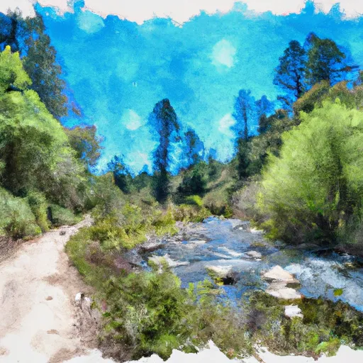
Wilderness Boundary To Forest Road 40n54 River Run
Community Reviews
Been here? Share the conditions.
Reviews, ratings & photos are added in the free Snoflo iOS app — rate a spot, tag the conditions, and your visit is verified by location. Add or manage your reviews from the app.
Wilderness Boundary To Forest Road 40n54
The class rating for this section ranges from Class III to IV, with some challenging Class IV rapids and obstacles. The segment mileage is approximately 7.5 miles, starting at the wilderness boundary and ending at Forest Road 40N54.
One of the most notable rapids in this section is called "Deadman's Drop," which is a Class IV rapid with a steep drop and large waves. Other challenging rapids include "Sidewinders" and "Tunnel Chute."
There are specific regulations in place for this area, including a permit requirement for overnight stays in the wilderness and a limit of 15 people per group. Additionally, visitors are required to pack out all trash and leave no trace.
Overall, the Wilderness Boundary to Forest Road 40N54 section of the Whitewater River offers a thrilling whitewater experience for experienced paddlers with a range of challenging rapids and beautiful scenery. It is important to check current flow conditions and obtain necessary permits before embarking on this adventure.
Plan your run down to the hour
Same weather feed Snoflo's iOS app uses -- updated continuously from NOAA / yr.no. Watch the precipitation column on the meteogram; rain ahead of a run typically lifts flows 12-48 hours later depending on the basin.
Next 5 days, hour by hour
Temperature line with weather symbols on top, snow + rain accumulation as columns, humidity as a dotted line.
5-day forecast table
Every 3 hours, broken out across temperature, snow, rain, humidity, and wind. Each cell is colour-coded relative to the column min/max.
| Time | Condition | Temp (°F) | Snow (in) | Rain (in) | Humidity (%) | Wind (mps) | Wind dir |
|---|---|---|---|---|---|---|---|
| Loading detailed forecast… | |||||||
15-day temperature & precipitation
Daily temperatures, snow, and rain projected over the next two weeks -- the upstream story that drives next week's flows.
Regional streamflow levels
USGS streamgauges around Wilderness Boundary To Forest Road 40n54 -- useful for spotting upstream pulses and gauging which tributary is contributing what.
| Streamgauge | Discharge | View |
|---|---|---|
| Trinity R Ab Coffee C Nr Trinity Ctr Ca | 28 cfs | → |
| Scott R Nr Fort Jones Ca | 30 cfs | → |
| Salmon R A Somes Bar Ca | 269 cfs | → |
| Klamath R A Orleans | 1,020 cfs | → |
| Shasta R Nr Montague Ca | 59 cfs | → |
| Nf Trinity R A Helena Ca | 47 cfs | → |
Plan a longer trip
The closest boat launches, other paddle runs, and campgrounds so a day on the water can grow into a full weekend.
Boat launches
- Jack Ass Creek River Access
- Red Bank River Access
- Saw Pit Flat River Access
- Matthews Creek River Access
- Methodist Creek River Access
- Nordheimer Flat River Access
Other river runs
- Headwaters In Russian Wilderness To Wilderness Boundary
- Scott District Boundary To Confluence With Sixmile Creek
- Headwaters In Marble Mountains Wilderness To Pre-1984 Wilderness Boundary
- Confluence With Sixmile Creek To Confluence With South Fork Salmon River
- Confluence With Blind Horse Creek To Cecilville Bridge
Campgrounds
- Idlewild Campground
- Mule Bridge - Horse
- Mulebridge Campground
- Trail Creek Campground
- Shadow Creek
- Hidden Horse Campground
Fishing spots
Whitewater safety
- Check the flow before you run
- Use the linked-gauge card and Regional Flow panel above. Class ratings change with flow -- a Class III at low water can become Class IV+ at high water.
- Know your skill ceiling
- Pick runs comfortably below your ceiling. Cold-water and big-water runs raise the consequences of any mistake.
- Wear the right gear
- Helmet, PFD, drysuit / wetsuit when water is below 60°F. Throw bag, knife, and whistle on your person, not in the boat.
- Scout, set safety, and run with a team
- Scout new rapids on foot, set safety with throw bags above the consequence pool, and run with at least one other competent paddler.
- Respect the river
- Strainers, undercuts, low-head dams, and wood can kill at any class rating. When in doubt, portage.
Set push alerts in the Snoflo app
Save Wilderness Boundary To Forest Road 40n54 as a favorite, set a discharge threshold (e.g. "alert me when flow hits 600 cfs"), and the iOS app pushes the moment the linked gauge crosses.
About Wilderness Boundary To Forest Road 40n54
What's the optimal flow for Wilderness Boundary To Forest Road 40n54?
The optimal flow depends on the section and the craft. Check the Run Details panel for the linked gauge and current status.
How fresh is the cfs reading on this page?
The linked USGS streamgauge reports continuously (every 15 minutes); Snoflo refreshes throughout the day. Hover the streamflow sparkline to read individual datapoints.
What's the whitewater class?
See the Run Details panel for the class rating Snoflo tracks for this run. Class ratings change with flow -- a Class III at low water can become Class IV in high water.
Where do I put in / take out?
Tap Directions in the hero above to open driving directions to the put-in. For shuttle planning, check the Nearby Boat Launches panel and the river run operator's site.
Can I get alerts when flows hit the optimal range?
Yes -- alerts are managed in the Snoflo iOS app. Favorite this run, set a discharge threshold, and you'll get a push the moment the gauge crosses.
Other runs near here
Snoflo-tracked paddle runs within driving distance of Wilderness Boundary To Forest Road 40n54.