Oregon Cascades Recreation Area Boundary To Mt. Thielsen Wilderness Boundary River Run
Community Reviews
Been here? Share the conditions.
Reviews, ratings & photos are added in the free Snoflo iOS app — rate a spot, tag the conditions, and your visit is verified by location. Add or manage your reviews from the app.
Oregon Cascades Recreation Area Boundary To Mt. Thielsen Wilderness Boundary
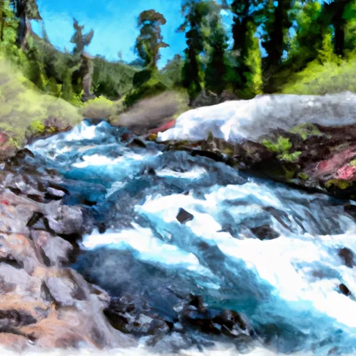
One of the most significant rapids on the Whitewater River run is called "Boxcar," which is a narrow chute that requires precise maneuvering. Other notable features include "S-Turn" and "Pinball," both of which require careful navigation to avoid obstacles.
The segment of the river is regulated by the US Forest Service, and visitors are required to obtain a permit before entering the area. Additionally, visitors must follow Leave No Trace principles and pack out all trash and waste. The use of glass containers and fires is prohibited, and visitors must follow all posted signs and regulations.
Overall, the Whitewater River run in the Oregon Cascades Recreation Area Boundary to Mt. Thielsen Wilderness Boundary offers a thrilling whitewater experience for experienced paddlers. It is essential to check the streamflow levels before planning a trip and to follow all regulations to help preserve the natural beauty of the area.
Plan your run down to the hour
Same weather feed Snoflo's iOS app uses -- updated continuously from NOAA / yr.no. Watch the precipitation column on the meteogram; rain ahead of a run typically lifts flows 12-48 hours later depending on the basin.
Next 5 days, hour by hour
Temperature line with weather symbols on top, snow + rain accumulation as columns, humidity as a dotted line.
5-day forecast table
Every 3 hours, broken out across temperature, snow, rain, humidity, and wind. Each cell is colour-coded relative to the column min/max.
| Time | Condition | Temp (°F) | Snow (in) | Rain (in) | Humidity (%) | Wind (mps) | Wind dir |
|---|---|---|---|---|---|---|---|
| Loading detailed forecast… | |||||||
15-day temperature & precipitation
Daily temperatures, snow, and rain projected over the next two weeks -- the upstream story that drives next week's flows.
Regional streamflow levels
USGS streamgauges around Oregon Cascades Recreation Area Boundary To Mt. Thielsen Wilderness Boundary -- useful for spotting upstream pulses and gauging which tributary is contributing what.
| Streamgauge | Discharge | View |
|---|---|---|
| North Umpqua R Bl Lemolo Lk Nr T Falls | 87 cfs | → |
| N.Umpqua R Abv White Mule Ck | 91 cfs | → |
| N.Umpqua R Blw Warm Springs Ck Nr Toketee Falls | 89 cfs | → |
| Lake Creek Near Diamond | 113 cfs | → |
| Clearwater R Ab Trap Cr Nr T Falls | 52 cfs | → |
| Clearwater R Blw Mowich Creek | 50 cfs | → |
Plan a longer trip
The closest boat launches, other paddle runs, and campgrounds so a day on the water can grow into a full weekend.
Boat launches
- East Lemolo
- Poole Creek
- Lemolo Lake Resort
- Digit Point Campground
- North End Boating Site (Diamond Lake)
- North End Boat Ramp
Other river runs
- Lemolo Lake To Oregon Cacades Recreation Area Boundary
- Mt. Thielsen Wilderness Boundary To Maidu Lake
- Lower Timpanogas Lake To Confluence With Echo Creek
- Headwaters To Rogue-Umpqua Wilderness Boundary
- Headwaters To Boulder Creek Wilderness Boundary
Campgrounds
- Kelsay Valley Campground
- Kelsay Valley Campground / Trailhead
- Kelsay Valley Trailhead Campground
- Inlet Campground
- East Lemolo Campground
- Linda Lake Forest Camp
Fishing spots
Whitewater safety
- Check the flow before you run
- Use the linked-gauge card and Regional Flow panel above. Class ratings change with flow -- a Class III at low water can become Class IV+ at high water.
- Know your skill ceiling
- Pick runs comfortably below your ceiling. Cold-water and big-water runs raise the consequences of any mistake.
- Wear the right gear
- Helmet, PFD, drysuit / wetsuit when water is below 60°F. Throw bag, knife, and whistle on your person, not in the boat.
- Scout, set safety, and run with a team
- Scout new rapids on foot, set safety with throw bags above the consequence pool, and run with at least one other competent paddler.
- Respect the river
- Strainers, undercuts, low-head dams, and wood can kill at any class rating. When in doubt, portage.
Set push alerts in the Snoflo app
Save Oregon Cascades Recreation Area Boundary To Mt. Thielsen Wilderness Boundary as a favorite, set a discharge threshold (e.g. "alert me when flow hits 600 cfs"), and the iOS app pushes the moment the linked gauge crosses.
About Oregon Cascades Recreation Area Boundary To Mt. Thielsen Wilderness Boundary
What's the optimal flow for Oregon Cascades Recreation Area Boundary To Mt. Thielsen Wilderness Boundary?
The optimal flow depends on the section and the craft. Check the Run Details panel for the linked gauge and current status.
How fresh is the cfs reading on this page?
The linked USGS streamgauge reports continuously (every 15 minutes); Snoflo refreshes throughout the day. Hover the streamflow sparkline to read individual datapoints.
What's the whitewater class?
See the Run Details panel for the class rating Snoflo tracks for this run. Class ratings change with flow -- a Class III at low water can become Class IV in high water.
Where do I put in / take out?
Tap Directions in the hero above to open driving directions to the put-in. For shuttle planning, check the Nearby Boat Launches panel and the river run operator's site.
Can I get alerts when flows hit the optimal range?
Yes -- alerts are managed in the Snoflo iOS app. Favorite this run, set a discharge threshold, and you'll get a push the moment the gauge crosses.
Other runs near here
Snoflo-tracked paddle runs within driving distance of Oregon Cascades Recreation Area Boundary To Mt. Thielsen Wilderness Boundary.