

-
 Snoflo Premium
Get unlimited access to all our content
With no Ad interruptions! - Start Your Free Trial Login with existing account
Suches
Eden Index
Climate
6.8
•
Recreation
7.1
•
Community
•
Safeguard
5.2/10
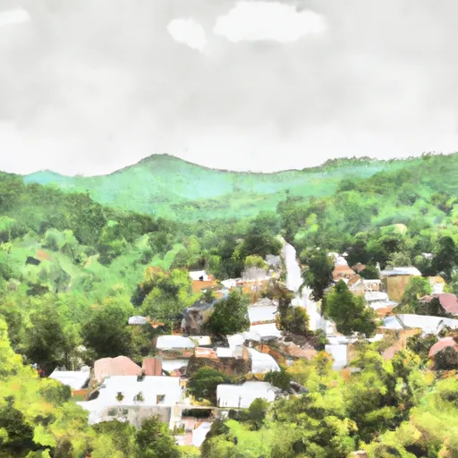
Suches, Georgia, also known as the "Valley Above the Clouds," is a small unincorporated community located in the southern Appalachian Mountains. It is nestled in Union County, surrounded by stunning natural beauty. The climate in Suches is classified as a humid subtropical climate, characterized by mild winters and warm summers. The area experiences abundant rainfall throughout the year, which contributes to its lush vegetation.
Hydrology plays a significant role in Suches, as the community is home to several rivers and streams. The Toccoa River, Noontootla Creek, and Cooper Creek flow through the area, providing ample opportunities for fishing, kayaking, and whitewater rafting. These waterways also attract nature enthusiasts who enjoy exploring their scenic surroundings.
Outdoor recreation opportunities are plentiful in Suches. The nearby Chattahoochee National Forest offers various activities, including hiking, camping, and wildlife viewing. The Appalachian Trail, one of the most iconic long-distance hiking trails in the United States, passes through the area, attracting hikers from all over the world. Additionally, the region is known for its excellent fishing spots, particularly for trout fishing.
In conclusion, Suches, Georgia, offers a picturesque setting with a mild climate and abundant hydrological features. With its proximity to national forests and outdoor recreational opportunities, it is a haven for nature lovers and adventure seekers alike.
What is the Eden Index?
The Snoflo Eden Index serves as a comprehensive rating system for regions, evaluating their desirability through a holistic assessment of climate health, outdoor recreation opportunities, and natural disaster risk, acknowledging the profound impact of these factors on livability and well-being.
Climate Health Indicator (CHI): 6.8
Suches receives approximately
1729mm of rain per year,
with humidity levels near 82%
and air temperatures averaging around
13°C.
Suches has a plant hardyness factor of
7, meaning
plants and agriculture in this region tend to thrive during the non-winter months.
By considering the ideal temperature range, reliable water supplies, clean air, and stable seasonal rain or snowpacks, the Climate Health Indicator (CHI) underscores the significance of a healthy climate as the foundation for quality living.
A healthy climate is paramount for ensuring a high quality of life and livability in a region, fostering both physical well-being and environmental harmony. This can be characterized by ideal temperatures, reliable access to water supplies, clean air, and consistent seasonal rain or snowpacks.
Weather Forecast
Streamflow Conditions
Middle Tennessee-Hiwassee
Area Rivers
Middle Tennessee-Hiwassee
Snowpack Depths
Middle Tennessee-Hiwassee
Reservoir Storage Capacity
Middle Tennessee-Hiwassee
Groundwater Levels
Recreational Opportunity Index (ROI): 7.1
The Recreational Opportunity Index (ROI) recognizes the value of outdoor recreational options, such as parks, hiking trails, camping sites, and fishing spots, while acknowledging that climate plays a pivotal role in ensuring the comfort and consistency of these experiences.
Access to outdoor recreational opportunities, encompassing activities such as parks, hiking, camping, and fishing, is crucial for overall well-being, and the climate plays a pivotal role in enabling and enhancing these experiences, ensuring that individuals can engage in nature-based activities comfortably and consistently.
Camping Areas
| Campground | Campsites | Reservations | Toilets | Showers | Elevation |
|---|---|---|---|---|---|
| Chestnut Ridge - Lake Lanier | None | 1,108 ft | |||
| Shoal Creek - Lake Lanier | None | 1,117 ft | |||
| Bald Ridge Creek | None | 1,097 ft | |||
| Indian Springs State Park | None | 503 ft | |||
| Stone Mountain Park Campground | 430 | 1,558 ft | |||
| High Falls State Park | None | 600 ft | |||
| Sawnee | None | 1,070 ft | |||
| Old Federal - Lake Lanier | None | 1,108 ft | |||
| Shady Grove - Lake Lanier | None | 1,113 ft | |||
| Charleston - Lake Lanier | None | 1,185 ft |
Nearby Ski Areas
Catastrophe Safeguard Index (CSI):
The Catastrophe Safeguard Index (CSI) recognizes that natural disaster risk, encompassing floods, fires, hurricanes, and tornadoes, can drastically affect safety and the overall appeal of an area.
The level of natural disaster risk in a region significantly affects safety and the overall livability, with climate change amplifying these risks by potentially increasing the frequency and intensity of events like floods, fires, hurricanes, and tornadoes, thereby posing substantial challenges to community resilience and well-being.
Community Resilience Indicator (CRI):
The Community Resilience Indicator (CRI) recognizes that education, healthcare, and socioeconomics are crucial to the well-being of a region. The CRI acknowledges the profound impact of these elements on residents' overall quality of life. By evaluating educational resources, healthcare accessibility, and economic inclusivity, the index captures the essential aspects that contribute to a thriving community, fostering resident satisfaction, equity, and social cohesion.